Carabaya Province
Carabaya | ||
|---|---|---|
Province | ||
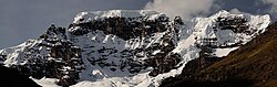 Allin Qhapaq, one of the highest mountains of the province | ||
| ||
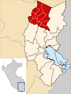 Location of Carabaya in the Puno Region | ||
| Country | Peru | |
| Region | Puno | |
| Capital | Macusani | |
| Government | ||
| • Mayor | Augusto Ronald Gutierrez Rodrigo | |
| Area | ||
| • Total | 12,266.4 km2 (4,736.1 sq mi) | |
| Elevation | 4,315 m (14,157 ft) | |
| Population | ||
| • Total | 66,316 | |
| • Density | 5.4/km2 (14/sq mi) | |
| UBIGEO | 2103 | |
| Website | www.municarabaya.gob.pe | |

Carabaya Province is a province of the Puno Region in the southern part of Peru.[1] It is bounded on the north by the Madre de Dios Region, on the east by the Sandia Province, on the south by the provinces of Azángaro, Melgar and Putina and on the west by the Cusco Region.[2] The capital of the province is the city of Macusani.
Contents
1 Geography
2 Political division
3 Ethnic groups
4 See also
5 References
6 External links
Geography
The province is traversed by the Willkanuta and Kallawaya mountain ranges. Some of the highest peaks of the province are Allin Qhapaq, Ch'ichi Qhapaq and Pumanuta. Other mountains are listed below:[3]
|
|
|
Ariquma Lake, Wiluyuq Qucha and Sayt'uquta belong to the largest lakes of the province.
Political division
The province measures 12,266.4 square kilometres (4,736.1 sq mi) and is divided into ten districts:
| District | Mayor | Capital | Ubigeo |
|---|---|---|---|
Ajoyani | Pedro Cutipa Quispe | Ajoyani | 210302 |
Ayapata | Hector Arraya Cuba | Ayapata | 210303 |
Coasa | N | Coasa | 210304 |
Corani | Edmundo caceres Guerra | Corani | 210305 |
Crucero | Max caceres Chui | Crucero | 210306 |
Ituata | N | Ituata | 210307 |
Macusani | Augusto Ronald Gutierrez rodrigo | Macusani | 210301 |
Ollachea | Juan Huayta C | Ollachea | 210308 |
San Gaban | Adolfo Huamantica | Lanlacuni Bajo | 210309 |
Usicayos | N | Usicayos | 210310 |
Ethnic groups
The people in the province are mainly indigenous citizens of Quechua descent. Quechua is the language which the majority of the population (84.12%) learnt to speak in childhood, 15.14% of the residents started speaking using the Spanish language and 0.62% Aymara (2007 Peru Census).[4]
See also
- Chawpiqucha
- Chichakuri
- Ch'uxñaquta
- Inambari River
- Kimsaqucha
- Parinaquta
Saytuqucha (Coasa)- Yawarmayu
References
^ (in Spanish) Instituto Nacional de Estadística e Informática. Banco de Información Digital Archived April 23, 2008, at the Wayback Machine., Retrieved December 29, 2007
^ escale.minedu.gob.pe - UGEL map of the Carabaya Province (Puno Region)
^ escale.minedu.gob.pe/ UGEL map Crucero District 2 (Puno Region)
^ inei.gob.pe Archived January 27, 2013, at the Wayback Machine. INEI, Peru, Censos Nacionales 2007
External links
(in Spanish) Official website
| |
|---|---|
|
This Puno Region geography article is a stub. You can help Wikipedia by expanding it. |
Coordinates: 14°04′10″S 70°25′52″W / 14.069501°S 70.431245°W / -14.069501; -70.431245


