Road signs in South Korea
Road signs in South Korea are regulated by the Korean Road Traffic Authority (Korean: 도로교통안전공단).
Signs indicating dangers are triangular with a red border, yellow background and black pictograms, similar to Road signs in Greece. Mandatory instructions are white on a blue background, prohibitions are black on a white background with a red border, and supplementary information signs are rectangular with black text on a white background. Like other countries, the signs use pictograms to display their meaning. Any text included in signs will normally be in Korean and English. Signs are normally placed 1 to 2.1 meters high.
South Korean road signs depict people with realistic (as opposed to stylized) silhouettes.
Road signs in South Korea closely followed Japanese and European rules on road signs until 1970s.
South Korea signed the Vienna Convention on Road Signs and Signals but has yet to ratify the Convention.
Contents
1 Warning signs
2 Prohibition signs
3 Mandatory instruction signs
4 Supplementary signs
5 Direction and distance signs
6 Other signs
7 References
8 External links
Warning signs
Warning signs are triangular with yellow backgrounds, red borders and black pictograms.

Crossroad

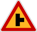
T-shaped intersection
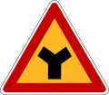
Y-shaped intersection
Intersection to right

Intersection to left

Through street

Traffic merge from right

Traffic merge from left

Traffic circle / Roundabout

Railway crossing

Right curve

Left curve

Double bend, the first to the right

Double bend, the first to the left
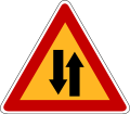
Two-way traffic

Ascending hill (10%)

Descending hill (10%)
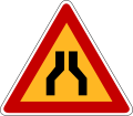
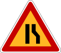
Narrow carriageway
Right lane decrease / End of right crawler lane

Left lane decrease / End of left crawler lane

Keep right

Pass left or right

Start of dual carriageway

End of dual carriageway
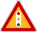
Traffic lights
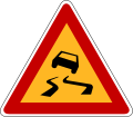
Slippery road

Riverside road (quayside or river bank)

Bumpy road

Speed humps

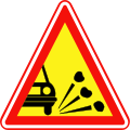
Falling rocks
Loose chippings (retired on September 28, 2007)

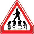
Crosswalk (pedestrian crossing)

Children crossing ahead

Bicycles

Roadworks
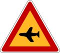
Airplanes

Crosswind

Tunnel
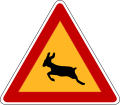
Wild animals crossing

Other dangers


Prohibition signs
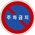
Prohibition signs are round with white backgrounds, red borders and black pictograms.

Road closed

No motor vehicles

No trucks

No buses

No motorcycles and mopeds

No motor vehicles, motorcycles and mopeds

No rotary tillers, tractors or handcarts

No tractors or rotary tillers (retired on September 28, 2007)

No oxcarts or horse-drawn carts (retired on September 28, 2007)

No handcarts (retired on September 28, 2007)

No bicycles

No entry
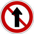
No straight ahead

No right turn

No left turn

No crossing traffic (retired on September 28, 2007)

No U-turn

No overtaking

No stopping or parking

No stopping or parking (retired)
No parking

No parking (retired)

Maximum weight limit (5.5t)

Height limit (3.5m)

Maximum width limit (2.2m)
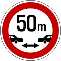
Minimum safe distance between vehicles (50m)

Maximum speed limit (50km/h)
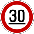
Minimum speed limit (30km/h)

No horn (retired)

Slow
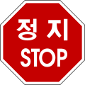
Stop

Stop (retired)
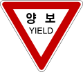
Yield
No pedestrian crossing (retired on September 28, 2007)

No pedestrians (retired on September 28, 2007)

No pedestrians

No vehicles carrying dangerous substances / explosives
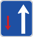
The traffic moving in the direction of the white arrow is given priority


Mandatory instruction signs
Mandatory instruction signs are round with blue backgrounds and white pictograms.

Motor Vehicles Only

Motor Vehicles Only (retired)

Bicycles Only

Bicycles and Pedestrians Only

Traffic circle / Roundabout

Straight

Right Turn

Left Turn

Straight and Right Turn

Straight and Left Turn

Left Turn and Right Turn

U-Turn

Pass Left or Right

Pass Right

Pass Left

Follow Directions

Diversion / Detour

Honk horn (retired)
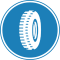
Mandatory use of snow tires or chains (retired)
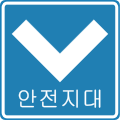
Safety zone (retired)

Parking Lot

Bicycle Parking Lot
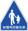
Pedestrians Only

Crosswalk (Pedestrian crossing)

Senior citizens crossing (In the Silver zone)

Children crossing (In the School zone)

Bicycles Crossing

One Way

One Way

One Way

Bus only Lane

HOV Lane


Supplementary signs
Supplementary signs are rectangular with white backgrounds and black text. Most of signs are only written in Korean.
District (Whole Downtown)

Date (Except for Sunday and Holidays)

Time

Time (You can park here within 1 hour)

Traffic light status (When the red light turned on)

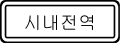
Front through road
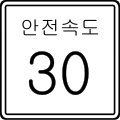
Safe speed (30 km/h)

Weather condition (foggy area)

Road condition (when snow or rain falls)

Traffic control (get in lane)

Traffic regulation (do not cross)

Vehicles limitation (only for sedans)

Sign explanation (tunnel length is 258m)

End (retired)
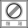
End (retired)

End

Tow-away zone


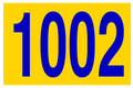
Direction and distance signs
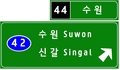
Direction and distance signs are rectangular with dark green backgrounds and white text. In urban areas, direction signs have dark blue backgrounds. The signs are normally written in Korean and English. In March 2010, Korea Expressway Corporation introduced a new type of direction sign for expressways.[1] Currently, Korea Expressway Corporation changes old direction signs to new ones on their expressways. This new type of direction sign is exit guide based sign and its typeface has changed from Sandol Doropyojipanche (Sandol traffic sign typeface, which can be seen on the distance sign and direction sign below) to Hangilche (Hangil typeface).

Distance sign

Direction sign (with name of junction)
New expressway direction sign (introduced in early 2010)


Other signs
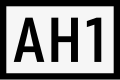
Asian Highway route shield
Expressway route shield
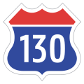
National Highway route shield
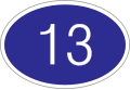
Local highway route shield

Urban Road route shield
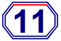
Urban expressway route shield


| Wikimedia Commons has media related to Road signs in South Korea. |
References
^ "Archived copy". Archived from the original on 2011-07-22. Retrieved 2010-11-28.CS1 maint: Archived copy as title (link).mw-parser-output cite.citation{font-style:inherit}.mw-parser-output .citation q{quotes:"""""""'""'"}.mw-parser-output .citation .cs1-lock-free a{background:url("//upload.wikimedia.org/wikipedia/commons/thumb/6/65/Lock-green.svg/9px-Lock-green.svg.png")no-repeat;background-position:right .1em center}.mw-parser-output .citation .cs1-lock-limited a,.mw-parser-output .citation .cs1-lock-registration a{background:url("//upload.wikimedia.org/wikipedia/commons/thumb/d/d6/Lock-gray-alt-2.svg/9px-Lock-gray-alt-2.svg.png")no-repeat;background-position:right .1em center}.mw-parser-output .citation .cs1-lock-subscription a{background:url("//upload.wikimedia.org/wikipedia/commons/thumb/a/aa/Lock-red-alt-2.svg/9px-Lock-red-alt-2.svg.png")no-repeat;background-position:right .1em center}.mw-parser-output .cs1-subscription,.mw-parser-output .cs1-registration{color:#555}.mw-parser-output .cs1-subscription span,.mw-parser-output .cs1-registration span{border-bottom:1px dotted;cursor:help}.mw-parser-output .cs1-ws-icon a{background:url("//upload.wikimedia.org/wikipedia/commons/thumb/4/4c/Wikisource-logo.svg/12px-Wikisource-logo.svg.png")no-repeat;background-position:right .1em center}.mw-parser-output code.cs1-code{color:inherit;background:inherit;border:inherit;padding:inherit}.mw-parser-output .cs1-hidden-error{display:none;font-size:100%}.mw-parser-output .cs1-visible-error{font-size:100%}.mw-parser-output .cs1-maint{display:none;color:#33aa33;margin-left:0.3em}.mw-parser-output .cs1-subscription,.mw-parser-output .cs1-registration,.mw-parser-output .cs1-format{font-size:95%}.mw-parser-output .cs1-kern-left,.mw-parser-output .cs1-kern-wl-left{padding-left:0.2em}.mw-parser-output .cs1-kern-right,.mw-parser-output .cs1-kern-wl-right{padding-right:0.2em}
External links
- Korean Road Traffic Authority
Road signs in Asia | |
|---|---|
| Sovereign states |
|
| States with limited recognition |
|
Dependencies and other territories |
|
| |


