Hohoe
Contents
1 Background
2 Tourism
3 References
4 External links
Background
Hohoe Hohoé | |
|---|---|
Town & District Capital | |
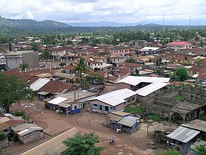 Hohoe city center | |
 Hohoe Location in Ghana | |
| Coordinates: 7°9′9″N 0°28′36″E / 7.15250°N 0.47667°E / 7.15250; 0.47667 | |
| Country | |
| Region | Volta Region |
| District | Hohoe Municipal District |
| Elevation | 535 ft (163 m) |
| Population (2012) | |
| • Total | 56,202[1] |
| Ranked 35th in Ghana | |
| Time zone | GMT |
| • Summer (DST) | GMT |
Hohoe Municipal is one of the 25 administrative districts of the Volta Region of Ghana. It was carved out of the former Kpando District. It was established by the Legislative Instrument (L.I. 2072) of 2012. The Municipality has a total land area of 1,172 km2, which is 5.6 percent of the land area of the region. It shares borders with the Republic of Togo on the east, forming part of Ghana’s international border; on the southeast by the Afadzato district and southwest by Kpando Municipality; on the north with Jasikan district; and on the northwest with the Biakoye districts [2]. Its capital, Hohoe, is about 78 kilometres from Ho, the regional capital and 220km from Accra, the national capital. The population of Hohoe Municipality, according to the 2010 Population and Housing Census, is 167,016 representing 7.9 percent of the total population of the Volta Region. It comprises of 52.1 percent females and 47.9 percent males[3]
Tourism
The Hohoe Municipality is a home of tourism potential capable of transforming its economy, as well as its overall contribution to national income when fully harnessed. It has a beautiful landscapes, numerous eco-tourism sites that make it one of the most important tourism areas in the country. The Hohoe Municipality has the following marked tourism features [4][5]:
i. The highest peak in Ghana Mt. Afadja (Afadjato) located between Liati Wote and Gbledi communities
ii. The highest waterfall in West Africa – Wli Waterfall located at Wli.
iii. Tsatsadu Waterfall located at Alavanyo
iv. Tagbo Waterfall at Liati Wote
v. Wadjakli Waterfall located at Likpe Todome
vi. The most wonderful ancient old iron mines at Akpafu –Todzi
vii. The four ancestoral caves located at Likpe-Todome
References
^ "World Gazetteer online". World-gazetteer.com. Archived from the original on 2012-01-11..mw-parser-output cite.citation{font-style:inherit}.mw-parser-output q{quotes:"""""""'""'"}.mw-parser-output code.cs1-code{color:inherit;background:inherit;border:inherit;padding:inherit}.mw-parser-output .cs1-lock-free a{background:url("//upload.wikimedia.org/wikipedia/commons/thumb/6/65/Lock-green.svg/9px-Lock-green.svg.png")no-repeat;background-position:right .1em center}.mw-parser-output .cs1-lock-limited a,.mw-parser-output .cs1-lock-registration a{background:url("//upload.wikimedia.org/wikipedia/commons/thumb/d/d6/Lock-gray-alt-2.svg/9px-Lock-gray-alt-2.svg.png")no-repeat;background-position:right .1em center}.mw-parser-output .cs1-lock-subscription a{background:url("//upload.wikimedia.org/wikipedia/commons/thumb/a/aa/Lock-red-alt-2.svg/9px-Lock-red-alt-2.svg.png")no-repeat;background-position:right .1em center}.mw-parser-output .cs1-subscription,.mw-parser-output .cs1-registration{color:#555}.mw-parser-output .cs1-subscription span,.mw-parser-output .cs1-registration span{border-bottom:1px dotted;cursor:help}.mw-parser-output .cs1-hidden-error{display:none;font-size:100%}.mw-parser-output .cs1-visible-error{font-size:100%}.mw-parser-output .cs1-subscription,.mw-parser-output .cs1-registration,.mw-parser-output .cs1-format{font-size:95%}.mw-parser-output .cs1-kern-left,.mw-parser-output .cs1-kern-wl-left{padding-left:0.2em}.mw-parser-output .cs1-kern-right,.mw-parser-output .cs1-kern-wl-right{padding-right:0.2em}
^ Ghana Statistical Service (2010). 2010 Population and Housing Census.
^ Ghana Statistical Service (2010). 2010 Population and Housing Census.
^ "Volta". Ghana Tourism Authourity. Retrieved 2018-11-30.
^ Anane-Amponsah, Mary. "Hohoe Municipality: Endowed in tourism but little investment". Graphic Online. Retrieved 2018-11-30.
External links
- Ghana-pedia webpage – Hohoe
[1]
Cities and towns of Ghana by population | ||
|---|---|---|
| 2,000,000+ |
|   |
| 1,000,000+ |
| |
| 800,000+ |
| |
| 100,000+ |
| |
| 80,000+ |
| |
| 60,000+ |
| |
| 40,000+ |
| |
| 20,000+ |
| |
| 5,000+ |
| |
| ||
District capitals in Ghana | |
|---|---|
| Ashanti Region |
|
| Brong-Ahafo Region | |
| Central Region | |
| Eastern Region | |
| Greater Accra Region | |
| Northern Region | |
| Upper East Region | |
| Upper West Region | |
| Volta Region | |
| Western Region | |
Regional capitals in bold | |
This Ghana location article is a stub. You can help Wikipedia by expanding it. |
Coordinates: 7°8′56.54″N 0°28′28.56″E / 7.1490389°N 0.4746000°E / 7.1490389; 0.4746000


