Huayopata District
Huayopata Wayupata | |
|---|---|
District | |
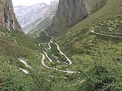 Near Allpamayu | |
| Country | |
| Region | Cusco |
| Province | La Convención |
| Founded | January 2, 1857 |
| Capital | Huyro |
| Area | |
| • Total | 524.02 km2 (202.33 sq mi) |
| Elevation | 1,650 m (5,410 ft) |
| Population (2005 census) | |
| • Total | 5,518 |
| • Density | 11/km2 (27/sq mi) |
| Time zone | UTC-5 (PET) |
| UBIGEO | 080903 |
Huayopata District is one of ten districts of the province La Convención in Peru.[1]
Geography
The Urupampa mountain range traverses the district. The highest peak of the district is Urupampa at 5,893 m (19,334 ft). Other mountains are listed below:[2]
- Inka Tampu Urqu
- Kuntur Sinqa
- K'urkur Urqu
- Marquni
- P'unquyuq
- Qillwaqucha
- Sara Sarayuq
- Tunki Urqu
- Waqay Willka
- Yana Urqu
- Yanantin
See also
- Allpamayu
- Inka Tampu
- Luq'umayu
- Quchapata
- Wamanmarka
References
^ (in Spanish) Instituto Nacional de Estadística e Informática. Banco de Información Distrital Archived 2008-04-23 at the Wayback Machine.. Retrieved April 11, 2008.
^ escale.minedu.gob.pe - UGEL map of the La Convención Province 1 (Cusco Region)
This Peruvian geography article is a stub. You can help Wikipedia by expanding it. |
| |
|---|---|
| Acomayo |
|
| Anta |
|
| Calca |
|
| Canas |
|
| Canchis |
|
| Chumbivilcas |
|
| Cusco |
|
| Espinar |
|
| La Convención |
|
| Paruro |
|
| Paucartambo |
|
| Quispicanchi |
|
| Urubamba |
|
Coordinates: 13°00′27″S 72°33′25″W / 13.00750°S 72.55694°W / -13.00750; -72.55694


