Nias
| Native name: Tanö Niha | |
|---|---|
 | |
| Geography | |
| Location | South East Asia |
| Coordinates | 1°6′N 97°32′E / 1.100°N 97.533°E / 1.100; 97.533Coordinates: 1°6′N 97°32′E / 1.100°N 97.533°E / 1.100; 97.533 |
| Area | 5,121.3 km2 (1,977.3 sq mi) |
| Highest elevation | 800 m (2,600 ft) |
| Highest point | unnamed |
| Administration | |
Indonesia | |
| Province | North Sumatra |
| Regencies | Nias, South Nias, North Nias, West Nias |
| Largest settlement | Gunungsitoli (pop. 126,202) |
| Demographics | |
| Population | 788,132 (2014 Estimate) |
| Pop. density | 147.8 /km2 (382.8 /sq mi) |
| Ethnic groups | Nias, Malay, Batak, and Chinese |
Nīas (Indonesian: Pulau Nias, Nias language: Tanö Niha) is an island located off the western coast of Sumatra, Indonesia. Nias is also the name of the archipelago (Kepulauan Nias) of which the island is the centre, but also includes the Batu Islands to the south-east and the small Hinako Islands. Nias Island covers an area of 5,121.3 km2 (1,977.3 sq mi) (including the minor offshore islands). It is mostly a lowland area rising to around 800 m (2,600 ft) above sea level. There were 756,338 inhabitants on the island (including minor offshore islands) at the 2010 Census. The latest estimate for January 2014 is 788,132.[1]
Contents
1 Geography
2 Administration
3 Culture
4 Transportation
5 Surfing
6 Tsunami and earthquakes of 2004 and 2005
7 Gallery
8 See also
9 References
10 External links
Geography

Location of Nias, Indonesia.
It is located in a chain of islands parallel to the west coast of Sumatra; Simeulue is about 140 km (87 mi) northwest, and the Batu Islands (which are administered as part of Nias and have an ethnically similar population) are located about 80 km (50 mi) southeast. This chain, which resurfaces in Nusa Tenggara in the mountainous islands of Sumba and Timor, is the forearc of the South Sumatra Basin along the Sunda Trench subduction zone.
At Nias the oceanic plate is being obliquely subducted under the Sunda Plate at the rapid rate of 52 mm (2.0 in) a year (Milsom).
Administration

Villagers in Bawomataluo on Nias move a megalith for construction around 1915.
Nias is the largest of the islands off Sumatra that are part of North Sumatra province. This archipelago consists of 131 islands, of which Nias Island is the biggest. The population in this area was 756,762 inhabitants at the 2010 Census, including Ono Niha (the indigenous inhabitants of the island), Malay, Batak, and Chinese; in January 2014 the population had risen to 788,132.[1]
Until 2003 Nias was a single administrative regency (kabupaten) covering the entire island, part of the province of North Sumatra. In 2003 it was split into two regencies, Nias and Nias Selatan (South Nias).[citation needed] Subsequently, the island was divided further, with the creation of two further regencies from parts of the former Nias Regency – Nias Barat (West Nias) and Nias Utara (North Nias) – and the designation of Gunungsitoli as an autonomous city independent of the four regencies. Gunungsitoli remains the capital city of Nias Regency and it is the center of the regency's administration and of the business affairs of the entire island. Teluk Dalam is the capital of Nias Selatan Regency, Lotu of Nias Utara Regency and Lahomi of Nias Barat Regency.
All parties in the North Sumatra Legislative Council have agreed to the formation of a Nias Island province (comprising Nias, Nias Selatan, Nias Utara and Nias Barat regencies, and Gunungsitoli municipality). It has been approved at a regional plenary session on 2 May 2011, but still awaits approval from Central government, which has not yet enacted the grand design for additional provinces. The new province will thus cover an area identical to the original Nias Regency prior to the latter's division in 2003.[2] Apart from Nias Island itself, the province will include the smaller Batu Islands (Pulau-pulau Batu) to the south, lying between Nias and Siberut; the Batu Islands form seven administrative districts within South Nias Regency.
| Name | Area (km2) | Population Census 2010 | Population Estimate January 2014[1] | Capital |
|---|---|---|---|---|
North Nias Regency (Nias Utara) | 1,203.7 | 127,244 | 132,593 | Lotu |
| Nias Regency | 809.7 | 131,377 | 136,900 | Gunungsitoli |
West Nias Regency (Nias Barat) | 473.7 | 81,807 | 85,246 | Lahomi |
South Nias Regency (Nias Selatan) | 1,825.5 | 289,708 | 301,886 | Teluk Dalam |
Gunungsitoli (city) | 280.8 | 126,202 | 131,507 | Gunungsitoli |
Culture

A man holding a Balato (sword) in a Nias war dance.
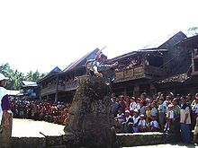
Nias ceremonial stone jump.
The first ancestors of Nias were Austromelanesoid race from Hoabinth at 10,000 B.C. and then came more advance Austronesians from Taiwan which shifted the existence of the Austromelanesoids.[3] The name of the island derives from the word used by the islanders to describe themselves, niha ("human").[4]
The isolated Nias Island chain has been trading since prehistory with other cultures, other islands, and even mainland Asia. Some historians and archaeologists have cited the local culture as one of the few remaining Megalithic cultures in existence today. While this point of view is hotly debated, there is no doubt that Nias' relative geographic isolation has created a unique culture. Nias is best known for its diversity of festivals and celebration. The most well-known events are War Dances, performed regularly for tourists, and Stone Jumping, a manhood ritual that sees young men leaping over two meter stone towers to their fate. In the past the top of the stone board is covered with spikes and sharp pointed bamboo. The music of Nias, performed mostly by women, is noted worldwide for its haunting beauty.[citation needed]
Gunungsitoli is home to Nias's only museum, the Museum Pusaka Nias (Nias Heritage Foundation),[5] which houses over 6000 objects related to Nias's cultural heritage. The museum had recently built a new building and had improved their storage and exhibitions when the 2004 earthquake and tsunami occurred. The museum suffered some damage to the grounds and collections, but museum staff are working to recover from this devastating event[6]
The predominant religion is Protestant Christianity. Six out of seven Niasans are Protestant; the remainder are about evenly divided between Muslim (mostly immigrants from elsewhere in Indonesia) and Catholic. However adherence to either Christian or Muslim religions is still largely symbolic; Nias continues into current day celebrating its own indigenous culture and traditions as the primary form of spiritual expression.
The people of Nias build omo sebua houses on massive ironwood pillars with towering roofs. Not only were they almost impregnable to attack in former tribal warfare, their flexible nail-less construction provide proven earthquake durability.
Nias is home not only to a unique human culture but also endemic fauna which differ from other areas of North Sumatra because of the island's remote location separate from Sumatra.
Transportation
To reach Nias, there is a weekly ship from Jakarta to Gunungsitoli; there were ferries from Sibolga to Gunungsitoli, Teluk Dalam, or Lahewa every day; before the Asian financial crisis hit Indonesia, there was a daily flight from Medan to Gunungsitoli. This became less frequent following the crisis.
Since the 1998 Reformation, however, transport links on and to the island have become poor. Internally, the road system is in a very bad condition. Externally the air and ferry links are unreliable. There are two ferry terminals (Gunungsitoli and Teluk Dalam) and an airport (Binaka, near Gunungsitoli[7]) on the island, serviced mainly from Sibolga and Medan respectively. However, local ferry companies regularly go out of business (or their boats sink), so only one terminal may be active at any given time. Since the 2005 earthquake, transportation has improved to cope with the increase in travel needs for reconstruction and rehabilitation efforts. Wings Air and Manunggal Air are the airlines that fly to Gunungsitoli.
Surfing

Surfing in Sorake

Coconut trees in Teluk Dalam
Nias is an internationally famous surfing destination. The best known surfing area is Sorake Bay, close to the town of Teluk Dalam, on the southern tip. Enclosed by the beaches of Lagundri and Sorake, the bay has both left and right-hand breaks. As they wait for waves, surfers can often see sea turtles swimming below. There are also two consistent, world-class waves in the nearby Hinako Islands, Asu and Bawa. Many lesser-known, high-quality surf spots with low crowds await adventurous travelers.
Nias was part of the famous Hippie trail of the 1960s, particularly traveled by surfers, which led to Bali. It has been the site of several international surfing competitions in the past, particularly before the 1998 Indonesian Reformation Movement.
Despite the storied history of surfing in Nias, international surfing in Nias has slowed down especially (but not specifically) due to the recent earthquakes.[8][9] The situation is slowly changing, however.[10][11]
Tsunami and earthquakes of 2004 and 2005

2005 Nias–Simeulue earthquake: U.S. Navy communicates with Military Sealift Command hospital ship USNS Mercy (T-AH-19) using Inmarsat satellite telephone in Nias (April 2005).
On December 26, 2004 the 2004 Indian Ocean earthquake struck a few kilometers north of the island, creating tsunamis as high as 10 metres (33 ft). 122 people were killed and hundreds more rendered homeless.
On March 28, 2005, the island was again hit by the 2005 Nias–Simeulue earthquake, initially presumed to be an aftershock of the 2004 quake, but now regarded as the second most powerful earthquake ever recorded in Indonesia and among the top 10 most powerful recorded worldwide since 1900.[12] At least 800 people were reported dead, with the possibility of more than 2,000 casualties. Hundreds of buildings were toppled and many thousands of people were made homeless. In 2007, almost two years after the earthquake, there were still tens of thousands of internally displaced persons living in camps throughout Nias.
Nias's coastline has changed markedly with the tsunami and earthquake.[13] In some areas, the coast moved over 50 m (160 ft) inland. In other areas, as much as a further 100 m (330 ft) of land is exposed. Uplift of land as much as 2.9 m (9.5 ft) has been recorded.
Following the earthquake, many international aid agencies moved in to assist in rehabilitation and reconstruction efforts. Oxfam, International Aid, Giving Children Hope, Save the Children Fund, World Vision, Surf Aid, Safe Harbor International and Caritas International are some of the international NGOs represented in Nias. UN agencies represented include UNORC – Office of the UN Recovery Coordinator for Aceh and Nias, UNDP, UNICEF, UN-Habitat, WFP, IOM and UNIDO.
Gallery

Family portrait of an older Nias princess with her daughters and granddaughters

Nias warrior.

Nias house.
Nias wedding.

Map of Nias and the westcoast of Sumatra betweet 1690 and 1743

Nias ancestor statue.

A band of Nias headhunters submitting to the Dutch.

Nias family.
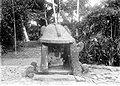
Nias place of sacrifice.

Nias armour.


See also
- List of islands of Indonesia
- Nias Expedition
- Omo sebua
References
^ abc http://www.depkes.go.id/downloads/Penduduk%20Kab%20Kota%20Umur%20Tunggal%202014.pdf Estimasi Penduduk Menurut Umur Tunggal Dan Jenis Kelamin 2014 Kementerian Kesehatan
^ Post, The Jakarta. "N. Sumatra to have two new provinces". thejakartapost.com..mw-parser-output cite.citation{font-style:inherit}.mw-parser-output q{quotes:"""""""'""'"}.mw-parser-output code.cs1-code{color:inherit;background:inherit;border:inherit;padding:inherit}.mw-parser-output .cs1-lock-free a{background:url("//upload.wikimedia.org/wikipedia/commons/thumb/6/65/Lock-green.svg/9px-Lock-green.svg.png")no-repeat;background-position:right .1em center}.mw-parser-output .cs1-lock-limited a,.mw-parser-output .cs1-lock-registration a{background:url("//upload.wikimedia.org/wikipedia/commons/thumb/d/d6/Lock-gray-alt-2.svg/9px-Lock-gray-alt-2.svg.png")no-repeat;background-position:right .1em center}.mw-parser-output .cs1-lock-subscription a{background:url("//upload.wikimedia.org/wikipedia/commons/thumb/a/aa/Lock-red-alt-2.svg/9px-Lock-red-alt-2.svg.png")no-repeat;background-position:right .1em center}.mw-parser-output .cs1-subscription,.mw-parser-output .cs1-registration{color:#555}.mw-parser-output .cs1-subscription span,.mw-parser-output .cs1-registration span{border-bottom:1px dotted;cursor:help}.mw-parser-output .cs1-hidden-error{display:none;font-size:100%}.mw-parser-output .cs1-visible-error{font-size:100%}.mw-parser-output .cs1-subscription,.mw-parser-output .cs1-registration,.mw-parser-output .cs1-format{font-size:95%}.mw-parser-output .cs1-kern-left,.mw-parser-output .cs1-kern-wl-left{padding-left:0.2em}.mw-parser-output .cs1-kern-right,.mw-parser-output .cs1-kern-wl-right{padding-right:0.2em}
^ "The First True Inhabitants of Nias". March 15, 2014.
^ Fernández-Armesto, Felipe (2010). "The Stranger-Effect in Early Modern Asia". Itinerario. 24 (02): 80. doi:10.1017/S0165115300013036. ISSN 0165-1153.
^ http://www.museum-nias.org/index.php
^ "Nias Artifacts Damaged in Powerful Earthquake". channelnewsasia.com.
^ Falling Rain Genomics. Airport BINAKA
^ Suwastoyo, Bhimanto (28 March 2006) Mail & Guardian Online. Indonesia's quake-hit surfers' paradise hopes for a break
^ Rinaldo, Rachel (February 15, 2004) Boots n' All Travel. Strange Days in Nias
^ (2006) Bali Advertiser. Surf Season
^ (2009) Indo Surf: Nias Surf
^ "Largest Earthquakes in the World Since 1900". U.S. Geological Survey. Archived from the original on November 7, 2010. Retrieved July 9, 2011.
^ Sieh, Kerry (June 1, 2005). "A Geologist in the Field" (PDF). Discover Magazine. Caltech. Retrieved March 2014. Check date values in:|accessdate=(help)
External links
 Media related to Nias at Wikimedia Commons
Wikisource has the text of the 1911 Encyclopædia Britannica article Nias. |
- Nias Island Website
- Nias Online
- Nias Bangkit


