Parsa District
Parsa District पर्सा जिल्ला | |
|---|---|
District | |
 The gate in Birganj on the Indo-Nepal border | |
 | |
| Country | Nepal |
| Province | Province No. 2 |
| Admin HQ. | Birganj |
| Government | |
| • Type | Coordination committee |
| • Body | DCC, Parsa |
| Area | |
| • Total | 1,353 km2 (522 sq mi) |
| Population (2011) | |
| • Total | 601,017 |
| • Density | 440/km2 (1,200/sq mi) |
| Time zone | UTC+5:45 (NPT) |
| Main Language(s) | Bhojpuri (90%), Nepali language(8%), Urdu(1%), others (1%) |
Parsa District (Nepali: पर्सा जिल्ला![]() Listen (help·info), a part of Province No. 2 in Terai plain, is one of the seventy-seven districts of Nepal. The district, with Birganj as its district headquarters, covers an area of 1,353 km² and has a population (2001) of 497,219. According to the locals, Parsa is named after Parsagadhi temple situated in the district.
Listen (help·info), a part of Province No. 2 in Terai plain, is one of the seventy-seven districts of Nepal. The district, with Birganj as its district headquarters, covers an area of 1,353 km² and has a population (2001) of 497,219. According to the locals, Parsa is named after Parsagadhi temple situated in the district.
Contents
1 Geography and Climate
2 Village Development Committees (VDCs) and municipalities
3 Municipalities
4 References
Geography and Climate
Climate Zone[1] | Elevation Range | % of Area |
|---|---|---|
| Lower Tropical | below 300 meters (1,000 ft) | 74.7% |
| Upper Tropical | 300 to 1,000 meters 1,000 to 3,300 ft. | 25.3n% |
Village Development Committees (VDCs) and municipalities
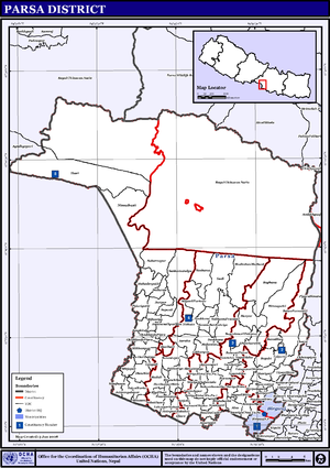
Map of the VDCs in Parsa District
- Alau,
- Amarpatti
- Auraha
- Bagahi
- Bagbana
- Bageshwari
- Bahauri Pidari
- Bahuarwa bhatha
- Basadilwa
- Basantpur
- Belwa Parsauni
- Beriya Birta
- Bhauratar
- Bhawanipur
- Bhedihari
- Bhisawa
- Bijbaniya
- Bindyabasini
- Biranchi Barwa
- Birganj Municipality
- Biruwa Guthi
- Bisrampur
- Chorani
- Deurbaana
- Dhaubini
- Gadi
- Gamhariya
- Ghoddauda Pipra
- Ghore
- Govindapur
- Hariharpur
- Hariharpur Birta
- Harapatganj
- Harpur
- Jagarnathpur Sira
- Jaimanglapur
- Janikatala
- Jhauwa Guthi
- Jitpur
- Kauwa Ban Kataiya
- Lahawarthakari
- Lakhanpur
- Lal Parsa
- Langadi
- Lipani Birta
- Madhuban Mathaul
- Mahadevpatti
- Mahuwan
- Mainiyari
- Mainpur
- Mikhampur
- Mirjapur
- Mosihani
- Mudali
- Nagardaha
- Nirchuta
- Nirmal Basti
- Pancharukhi
- Parsauni Birta
- Parsauni Matha
- Patbari Tola-Warwa
- Paterwa Sugauli
- Pidariguthi
- Pokhariya Municipality
- Phulwariya
Prasurampur[katti baluwa]- Ramgadhawa
- Ramnagari
- Sabaithawa
- Sakhuwa Prasauni
- Samjhauta
- Sankar Saraiya
- Sapauli
- Sedhawa
- Shiva Worga
- Sirsiya Khalwatola
- Sonbarsa
- Srisiya
- Subarnapur
- Sugauli Birta
- Sugauli Partewa
- Surjaha
- Thori
- Tulsi Barba
- Udaypur Dhursi
Municipalities
Birganj ( Metropolitan city )- Pokhariya
- Bahudarmai,Nepal
- Parsagadhi
References
^
The Map of Potential Vegetation of Nepal - a forestry/agroecological/biodiversity classification system (PDF), Forest & Landscape Development and Environment Series 2-2005 and CFC-TIS Document Series No.110., 2005, ISBN 87-7903-210-9, retrieved Nov 22, 2013.mw-parser-output cite.citation{font-style:inherit}.mw-parser-output q{quotes:"""""""'""'"}.mw-parser-output code.cs1-code{color:inherit;background:inherit;border:inherit;padding:inherit}.mw-parser-output .cs1-lock-free a{background:url("//upload.wikimedia.org/wikipedia/commons/thumb/6/65/Lock-green.svg/9px-Lock-green.svg.png")no-repeat;background-position:right .1em center}.mw-parser-output .cs1-lock-limited a,.mw-parser-output .cs1-lock-registration a{background:url("//upload.wikimedia.org/wikipedia/commons/thumb/d/d6/Lock-gray-alt-2.svg/9px-Lock-gray-alt-2.svg.png")no-repeat;background-position:right .1em center}.mw-parser-output .cs1-lock-subscription a{background:url("//upload.wikimedia.org/wikipedia/commons/thumb/a/aa/Lock-red-alt-2.svg/9px-Lock-red-alt-2.svg.png")no-repeat;background-position:right .1em center}.mw-parser-output .cs1-subscription,.mw-parser-output .cs1-registration{color:#555}.mw-parser-output .cs1-subscription span,.mw-parser-output .cs1-registration span{border-bottom:1px dotted;cursor:help}.mw-parser-output .cs1-hidden-error{display:none;font-size:100%}.mw-parser-output .cs1-visible-error{font-size:100%}.mw-parser-output .cs1-subscription,.mw-parser-output .cs1-registration,.mw-parser-output .cs1-format{font-size:95%}.mw-parser-output .cs1-kern-left,.mw-parser-output .cs1-kern-wl-left{padding-left:0.2em}.mw-parser-output .cs1-kern-right,.mw-parser-output .cs1-kern-wl-right{padding-right:0.2em}
"Districts of Nepal". Statoids.
| Wikimedia Commons has media related to Parsa District. |
Parsa District | ||
|---|---|---|
Headquarter: Birganj | ||
| 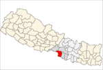 | |
Provinces and Districts of Nepal | ||
|---|---|---|
| Province No. 1 |
|  |
| Province No. 2 |
| |
| Province No. 3 |
| |
| Gandaki Pradesh |
| |
| Province No. 5 |
| |
| Karnali Pradesh |
| |
| Sudurpashchim Pradesh |
| |
Coordinates: 27°0′N 84°52′E / 27.000°N 84.867°E / 27.000; 84.867
This Nepalese location article is a stub. You can help Wikipedia by expanding it. |


