Henichesk
Henichesk Генічеськ | |||
|---|---|---|---|
City | |||
 | |||
| |||
 Location of Henichesk | |||
| Coordinates: 46°10′N 34°48′E / 46.167°N 34.800°E / 46.167; 34.800Coordinates: 46°10′N 34°48′E / 46.167°N 34.800°E / 46.167; 34.800 | |||
| Country | |||
| Oblast | |||
| Raion | |||
| Founded | 1784 | ||
| City status | 1938 | ||
| Area | |||
| • Total | 7.04 km2 (2.72 sq mi) | ||
| Elevation | 16 m (52 ft) | ||
| Population (2015) | |||
| • Total | 19,983 | ||
| • Density | 2,800/km2 (7,400/sq mi) | ||
| Postal code | 75500-75509 | ||
| Area code(s) | (+380) 5534 | ||
| Vehicle registration | BT / 22 | ||
| Website | www.genichesk.com.ua | ||
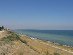
Henichesk (Ukrainian: Гені́чеськ, translit. Heniches’k) is a port city along the Sea of Azov in Kherson Oblast (province) of southern Ukraine. It serves as the administrative center of Henichesk Raion (district). Population: 19,983 (2015 est.)[1]
Contents
1 History
2 Gallery
3 Climate
4 Notable people
5 References
6 External links
History
Henichesk was founded as a fort by the Russian Empire in 1784 and from 1812 was also known as Ust-Ozivske. It was a port and a trade center on the salt route that went from Crimea north to Ukraine and Russia. At the turn of the 20th century it was the location of one of the largest flour mills in southern Ukraine. [2]
Gallery

P47 road entering Henichesk

Ukrainian-Georgian friendship monument

House of culture

Former Revkom building in Henichesk

Ambulance station

Old map of Henichesk Strait
Climate
Under the Köppen climate classification, Henichesk has a humid continental climate that closely borders on a semi-arid climate with cold winters and warm summers.
| Climate data for Henichesk (1891–2005) | |||||||||||||
|---|---|---|---|---|---|---|---|---|---|---|---|---|---|
| Month | Jan | Feb | Mar | Apr | May | Jun | Jul | Aug | Sep | Oct | Nov | Dec | Year |
| Record high °C (°F) | 14.1 (57.4) | 17.0 (62.6) | 22.4 (72.3) | 27.8 (82) | 31.8 (89.2) | 37.1 (98.8) | 38.3 (100.9) | 38.4 (101.1) | 33.6 (92.5) | 29.1 (84.4) | 22.3 (72.1) | 16.3 (61.3) | 38.4 (101.1) |
| Average high °C (°F) | 0.5 (32.9) | 0.9 (33.6) | 5.2 (41.4) | 12.7 (54.9) | 19.9 (67.8) | 25.0 (77) | 28.0 (82.4) | 27.1 (80.8) | 21.9 (71.4) | 14.9 (58.8) | 8.3 (46.9) | 3.0 (37.4) | 14.0 (57.2) |
| Daily mean °C (°F) | −2.1 (28.2) | −2.0 (28.4) | 1.9 (35.4) | 9.0 (48.2) | 16.0 (60.8) | 20.8 (69.4) | 23.5 (74.3) | 22.5 (72.5) | 17.4 (63.3) | 11.1 (52) | 5.5 (41.9) | 0.5 (32.9) | 10.4 (50.7) |
| Average low °C (°F) | −4.6 (23.7) | −4.6 (23.7) | −0.7 (30.7) | 5.7 (42.3) | 11.8 (53.2) | 16.0 (60.8) | 18.3 (64.9) | 17.5 (63.5) | 12.9 (55.2) | 7.5 (45.5) | 3.0 (37.4) | −1.8 (28.8) | 6.8 (44.2) |
| Record low °C (°F) | −30.3 (−22.5) | −28.0 (−18.4) | −18.4 (−1.1) | −9.0 (15.8) | −2.2 (28) | 0.2 (32.4) | 8.4 (47.1) | 6.0 (42.8) | −5.4 (22.3) | −12.2 (10) | −20.8 (−5.4) | −22.1 (−7.8) | −30.3 (−22.5) |
| Average precipitation mm (inches) | 34.7 (1.37) | 30.8 (1.21) | 30.7 (1.21) | 30.1 (1.19) | 35.1 (1.38) | 40.6 (1.6) | 35.7 (1.41) | 27.9 (1.1) | 27.4 (1.08) | 25.6 (1.01) | 32.9 (1.3) | 36.1 (1.42) | 387.7 (15.26) |
| Average precipitation days | 18.2 | 16.6 | 13.9 | 9.0 | 5.9 | 8.3 | 3.6 | 4.1 | 7.8 | 9.6 | 17.8 | 16.0 | 130.8 |
| Average relative humidity (%) | 88.5 | 85.7 | 81.6 | 75.1 | 65.7 | 66.3 | 66.8 | 65.2 | 74.8 | 77.2 | 87.5 | 86.7 | 76.8 |
| Mean monthly sunshine hours | 46.5 | 77.0 | 130.2 | 208.5 | 308.5 | 306.0 | 311.6 | 310.0 | 232.5 | 161.2 | 55.5 | 43.4 | 2,190.8 |
| Source: Climatebase.ru[3] | |||||||||||||
Notable people
- Yosyp Abramovych Daits,[4] Ukrainian artist (August 16, 1897 - December 29, 1954)
References
^ "Чисельність наявного населення України (Actual population of Ukraine)" (PDF) (in Ukrainian). State Statistics Service of Ukraine. Retrieved 1 July 2016..mw-parser-output cite.citation{font-style:inherit}.mw-parser-output q{quotes:"""""""'""'"}.mw-parser-output code.cs1-code{color:inherit;background:inherit;border:inherit;padding:inherit}.mw-parser-output .cs1-lock-free a{background:url("//upload.wikimedia.org/wikipedia/commons/thumb/6/65/Lock-green.svg/9px-Lock-green.svg.png")no-repeat;background-position:right .1em center}.mw-parser-output .cs1-lock-limited a,.mw-parser-output .cs1-lock-registration a{background:url("//upload.wikimedia.org/wikipedia/commons/thumb/d/d6/Lock-gray-alt-2.svg/9px-Lock-gray-alt-2.svg.png")no-repeat;background-position:right .1em center}.mw-parser-output .cs1-lock-subscription a{background:url("//upload.wikimedia.org/wikipedia/commons/thumb/a/aa/Lock-red-alt-2.svg/9px-Lock-red-alt-2.svg.png")no-repeat;background-position:right .1em center}.mw-parser-output .cs1-subscription,.mw-parser-output .cs1-registration{color:#555}.mw-parser-output .cs1-subscription span,.mw-parser-output .cs1-registration span{border-bottom:1px dotted;cursor:help}.mw-parser-output .cs1-hidden-error{display:none;font-size:100%}.mw-parser-output .cs1-visible-error{font-size:100%}.mw-parser-output .cs1-subscription,.mw-parser-output .cs1-registration,.mw-parser-output .cs1-format{font-size:95%}.mw-parser-output .cs1-kern-left,.mw-parser-output .cs1-kern-wl-left{padding-left:0.2em}.mw-parser-output .cs1-kern-right,.mw-parser-output .cs1-kern-wl-right{padding-right:0.2em}
^ http://www.encyclopediaofukraine.com/display.asp?linkpath=pages%5CH%5CE%5CHenichesk.htm
^ "Genicesk, Ukraine Climate data (Period supervision: 1891–2005)". Climatebase. Retrieved April 6, 2015.
^ http://kharkov.vbelous.net/english/artists/daits.htm
External links
| Wikimedia Commons has media related to Henichesk. |
- Non-official city site
This article about a location in Kherson Oblast is a stub. You can help Wikipedia by expanding it. |


