New Lebanon, New York
| New Lebanon, New York | |
|---|---|
| Town | |
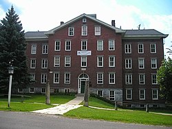 Darrow School, formerly the Mount Lebanon Shaker Society | |
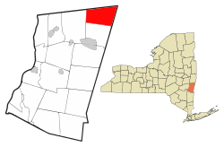 Location of New Lebanon, New York | |
| Coordinates: 42°28′0″N 73°26′36″W / 42.46667°N 73.44333°W / 42.46667; -73.44333 | |
| Country | United States |
| State | New York |
| County | Columbia |
| Government | |
| • Type | Town Council |
| • Town Supervisor | Micaela Dermody (D) |
| • Town Council | Members' List
|
| Area[1] | |
| • Total | 35.95 sq mi (93.10 km2) |
| • Land | 35.83 sq mi (92.80 km2) |
| • Water | 0.12 sq mi (0.30 km2) |
| Elevation | 1,306 ft (398 m) |
| Population (2010) | |
| • Total | 2,305 |
| • Estimate (2016)[2] | 2,206 |
| • Density | 61.57/sq mi (23.77/km2) |
| Time zone | UTC-5 (Eastern (EST)) |
| • Summer (DST) | UTC-4 (EDT) |
| ZIP code | 12125 |
| Area code(s) | 518 Exchange: 794 |
| FIPS code | 36-021-50452 |
GNIS feature ID | 0979267 |
| Website | townofnewlebanon.com |
New Lebanon is a town in Columbia County, New York, United States, 24 miles (39 km) southeast of Albany. In 1910, 1,378 people lived in New Lebanon. The population was 2,305 at the 2010 census.[3]
The town of New Lebanon is in the northeast corner of Columbia County. The center of town is at the intersection of U.S. Route 20 and New York State Route 22.
Contents
1 History
1.1 Past residents of note
2 Geography
3 Demographics
4 Communities and locations in New Lebanon
5 References
6 External links
History
New Lebanon was formed from the town of Canaan in 1818.
New Lebanon was the main spiritual home of the Shakers. The Mount Lebanon Shaker Society had 609 members in 1864. The most historic structures now belong to the Shaker Museum | Mount Lebanon. Some of the other surviving buildings are home to the Darrow School. Still others have been converted into a Sufi retreat center called the Abode of the Message. The latter is the former residence of Vilayat Inayat Khan, and is now the home of the current Pir of the Inayati Order, Zia Inayat Khan.
In addition to the Mount Lebanon Shaker Society, the Church of Our Saviour, Donnelly House, Elisha Gilbert House, Lebanon Springs Union Free School, and Gov. Samuel J. Tilden Monument are listed on the National Register of Historic Places.[4]
Past residents of note
Samuel J. Tilden, New York politician and U. S. presidential candidate in 1876. (Tilden won the popular vote but was defeated by Hayes in the electoral college.)
George Henry Williams, attorney and judge
Geography
According to the United States Census Bureau, the town has a total area of 36.0 square miles (93.2 km2), of which 35.9 square miles (92.9 km2) is land and 0.12 square miles (0.3 km2), or 0.32%, is water.[3]
The north town line is the border of Rensselaer County, New York, and the east town line is the border of Berkshire County, Massachusetts.
Demographics
| Historical population | |||
|---|---|---|---|
| Census | Pop. | %± | |
| 1820 | 2,808 | — | |
| 1830 | 2,695 | −4.0% | |
| 1840 | 2,536 | −5.9% | |
| 1850 | 2,300 | −9.3% | |
| 1860 | 2,187 | −4.9% | |
| 1870 | 2,124 | −2.9% | |
| 1880 | 2,245 | 5.7% | |
| 1890 | 1,765 | −21.4% | |
| 1900 | 1,556 | −11.8% | |
| 1910 | 1,378 | −11.4% | |
| 1920 | 1,133 | −17.8% | |
| 1930 | 1,081 | −4.6% | |
| 1940 | 1,259 | 16.5% | |
| 1950 | 1,415 | 12.4% | |
| 1960 | 1,674 | 18.3% | |
| 1970 | 2,035 | 21.6% | |
| 1980 | 2,271 | 11.6% | |
| 1990 | 2,379 | 4.8% | |
| 2000 | 2,454 | 3.2% | |
| 2010 | 2,305 | −6.1% | |
| Est. 2016 | 2,206 | [2] | −4.3% |
| U.S. Decennial Census[5] | |||
As of the census[6] of 2000, there were 2,454 people, 983 households, and 651 families residing in the town. The population density was 68.4 people per square mile (26.4/km²). There were 1,201 housing units at an average density of 33.5 per square mile (12.9/km²). The racial makeup of the town was 95.52% White, 1.26% African American, 0.08% Native American, 1.34% Asian, 0.16% Pacific Islander, 0.41% from other races, and 1.22% from two or more races. Hispanic or Latino of any race was 1.10% of the population.
There were 983 households out of which 30.2% had children under the age of 18 living with them, 50.7% were married couples living together, 10.8% had a female householder with no husband present, and 33.7% were non-families. 26.3% of all households were made up of individuals and 9.1% had someone living alone who was 65 years of age or older. The average household size was 2.38 and the average family size was 2.87.
In the town, the population was spread out with 26.1% under the age of 18, 6.3% from 18 to 24, 26.0% from 25 to 44, 28.7% from 45 to 64, and 12.9% who were 65 years of age or older. The median age was 40 years. For every 100 females, there were 95.5 males. For every 100 females age 18 and over, there were 94.6 males.
The median income for a household in the town was $44,805, and the median income for a family was $50,417. Males had a median income of $34,524 versus $30,590 for females. The per capita income for the town was $20,529. About 6.8% of families and 9.0% of the population were below the poverty line, including 15.7% of those under age 18 and 4.7% of those age 65 or over.
Communities and locations in New Lebanon
Darrow School – formerly a boys' prep school, now coeducational boarding school.
Lebanon Springs – A hamlet northeast of New Lebanon village on Route 22.
New Britain – A hamlet in the southwest part of the town.
New Lebanon – The hamlet of New Lebanon in the eastern part of the town.
New Lebanon Center – A hamlet west of New Lebanon village.
The Abode of the Message – A residential spiritual community, conference center and school of esoteric study.
West Lebanon – A hamlet in the northwest part of the town on Route 20.
References
^ "2016 U.S. Gazetteer Files". United States Census Bureau. Retrieved Jul 4, 2017..mw-parser-output cite.citation{font-style:inherit}.mw-parser-output q{quotes:"""""""'""'"}.mw-parser-output code.cs1-code{color:inherit;background:inherit;border:inherit;padding:inherit}.mw-parser-output .cs1-lock-free a{background:url("//upload.wikimedia.org/wikipedia/commons/thumb/6/65/Lock-green.svg/9px-Lock-green.svg.png")no-repeat;background-position:right .1em center}.mw-parser-output .cs1-lock-limited a,.mw-parser-output .cs1-lock-registration a{background:url("//upload.wikimedia.org/wikipedia/commons/thumb/d/d6/Lock-gray-alt-2.svg/9px-Lock-gray-alt-2.svg.png")no-repeat;background-position:right .1em center}.mw-parser-output .cs1-lock-subscription a{background:url("//upload.wikimedia.org/wikipedia/commons/thumb/a/aa/Lock-red-alt-2.svg/9px-Lock-red-alt-2.svg.png")no-repeat;background-position:right .1em center}.mw-parser-output .cs1-subscription,.mw-parser-output .cs1-registration{color:#555}.mw-parser-output .cs1-subscription span,.mw-parser-output .cs1-registration span{border-bottom:1px dotted;cursor:help}.mw-parser-output .cs1-hidden-error{display:none;font-size:100%}.mw-parser-output .cs1-visible-error{font-size:100%}.mw-parser-output .cs1-subscription,.mw-parser-output .cs1-registration,.mw-parser-output .cs1-format{font-size:95%}.mw-parser-output .cs1-kern-left,.mw-parser-output .cs1-kern-wl-left{padding-left:0.2em}.mw-parser-output .cs1-kern-right,.mw-parser-output .cs1-kern-wl-right{padding-right:0.2em}
^ ab "Population and Housing Unit Estimates". Retrieved June 9, 2017.
^ ab "Geographic Identifiers: 2010 Demographic Profile Data (G001): New Lebanon town, Columbia County, New York". U.S. Census Bureau, American Factfinder. Retrieved December 11, 2014.
^ National Park Service (2010-07-09). "National Register Information System". National Register of Historic Places. National Park Service.
^ "Census of Population and Housing". Census.gov. Retrieved June 4, 2015.
^ "American FactFinder". United States Census Bureau. Retrieved 2008-01-31.
External links
![]() Media related to New Lebanon, New York at Wikimedia Commons
Media related to New Lebanon, New York at Wikimedia Commons
- Town of New Lebanon official website
- New Lebanon Library
- Historical information about New Lebanon
"Mysteries of the Tyringham Shakers unmasked: A new examination of people, facts, and figures"[permanent dead link]
- The Theater Barn (Nonprofit summer-stock theater operating in New Lebanon since 1984)
Coordinates: 42°27′50″N 73°23′47″W / 42.46389°N 73.39639°W / 42.46389; -73.39639
Municipalities and communities of Columbia County, New York, United States | ||
|---|---|---|
County seat: Hudson | ||
| City |
|  |
| Towns |
| |
| Villages |
| |
| CDPs |
| |
| Other hamlets |
| |
| Footnotes | ‡This populated place also has portions in an adjacent county or counties | |


