Moro Gulf
| Moro Gulf | |
|---|---|
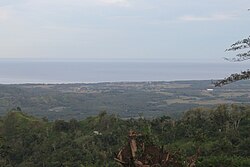 The gulf seen from Lebak | |
 Moro Gulf Location within the Philippines Show map of Mindanao  Moro Gulf Moro Gulf (Philippines) Show map of Philippines | |
| Location | Mindanao Island |
| Coordinates | 6°51′00″N 123°00′00″E / 6.8500°N 123.0000°E / 6.8500; 123.0000Coordinates: 6°51′00″N 123°00′00″E / 6.8500°N 123.0000°E / 6.8500; 123.0000 |
| Type | gulf |
| Etymology | Moro |
| Part of | Celebes Sea |
| Settlements |
|
The Moro Gulf is the largest gulf in the Philippines. It located off the coast of Mindanao Island, and is part of the Celebes Sea. The gulf is one of the country's tuna fishing grounds.[1]
Contents
1 Geography
2 Earthquakes
3 See also
4 References
Geography
The gulf stretches between and is surrounded by the main section of Mindanao on the east, and the Zamboanga Peninsula of Mindanao on the west. The peninsula's major drainage goes towards the gulf.[2]
Sibuguey Bay and Illana Bay are its major bays.
Zamboanga City, which is an international port, is bound by the Gulf and Celebes Sea in the East.[3]Cotabato City, on the eastern coast, is another major port.
Earthquakes
The Moro Gulf is also an area of significant tectonic activity with several fault zones in the region capable of producing major earthquakes and destructive local tsunamis, such as the devastating 1976 Moro Gulf earthquake which killed over 5,000 people and left over 90,000 people homeless as it hit the west coast of Mindanao.

See also
- Celebes Sea
- List of earthquakes in the Philippines
- Port of Zamboanga
References
^ Barut, Noel. "National Tuna Fishery Report - Philippines" (PDF). School of Ocean and Earth Science and Technology. Marine Fisheries Research Division National Fisheries Research and Development Institute. Retrieved 4 May 2015..mw-parser-output cite.citation{font-style:inherit}.mw-parser-output q{quotes:"""""""'""'"}.mw-parser-output code.cs1-code{color:inherit;background:inherit;border:inherit;padding:inherit}.mw-parser-output .cs1-lock-free a{background:url("//upload.wikimedia.org/wikipedia/commons/thumb/6/65/Lock-green.svg/9px-Lock-green.svg.png")no-repeat;background-position:right .1em center}.mw-parser-output .cs1-lock-limited a,.mw-parser-output .cs1-lock-registration a{background:url("//upload.wikimedia.org/wikipedia/commons/thumb/d/d6/Lock-gray-alt-2.svg/9px-Lock-gray-alt-2.svg.png")no-repeat;background-position:right .1em center}.mw-parser-output .cs1-lock-subscription a{background:url("//upload.wikimedia.org/wikipedia/commons/thumb/a/aa/Lock-red-alt-2.svg/9px-Lock-red-alt-2.svg.png")no-repeat;background-position:right .1em center}.mw-parser-output .cs1-subscription,.mw-parser-output .cs1-registration{color:#555}.mw-parser-output .cs1-subscription span,.mw-parser-output .cs1-registration span{border-bottom:1px dotted;cursor:help}.mw-parser-output .cs1-hidden-error{display:none;font-size:100%}.mw-parser-output .cs1-visible-error{font-size:100%}.mw-parser-output .cs1-subscription,.mw-parser-output .cs1-registration,.mw-parser-output .cs1-format{font-size:95%}.mw-parser-output .cs1-kern-left,.mw-parser-output .cs1-kern-wl-left{padding-left:0.2em}.mw-parser-output .cs1-kern-right,.mw-parser-output .cs1-kern-wl-right{padding-right:0.2em}
^ Carating, Rodelio B. (2014). Soils of the Philippines: World soils book series. Springer Science & Business. p. 61. ISBN 9401786828. Retrieved 4 May 2015.
^ "ZAMBOANGA PENINSULA". Department of Environment and Natural Resources. Retrieved 4 May 2015.
Seas of the Philippines | ||
|---|---|---|
| Ocean |
|  |
| Sea |
| |
| Strait |
| |
| Gulf |
| |
See also: Bodies of water of the Philippines | ||
Earth's oceans and seas | |
|---|---|
| Arctic Ocean |
|
| Atlantic Ocean |
|
| Indian Ocean |
|
| Pacific Ocean |
|
| Southern Ocean |
|
| Endorheic basins |
|
| |
Authority control |
|
|---|
This article about a Philippine location is a stub. You can help Wikipedia by expanding it. |


