Kuşadası
Kuşadası | |
|---|---|
District of Aydın Province | |
 An aerial view of Kuşadası | |
 Kuşadası | |
| Coordinates: 37°51′35″N 27°15′35″E / 37.85972°N 27.25972°E / 37.85972; 27.25972Coordinates: 37°51′35″N 27°15′35″E / 37.85972°N 27.25972°E / 37.85972; 27.25972 | |
| Country | Turkey |
| Province | Aydın |
| District | Kuşadası |
| Government | |
| • Mayor | Özer Kayalı (CHP) |
| • Kaymakam | Mustafa Esen |
| Area [1] | |
| • District | 224.60 km2 (86.72 sq mi) |
| Population (2012)[2] | |
| • Urban | 70,143 |
| • District | 90,652 |
| • District density | 400/km2 (1,000/sq mi) |
| Post code | 09400 |
| Website | www.kusadasi.bel.tr |
Kuşadası (pronounced [ˈkuʃadasɯ]) is a resort town on Turkey's Aegean coast, and the center of the seaside district of the same name within Aydın Province. Kuşadası is 95 km (59 mi) south of İzmir, and 71 km (44 mi) from Aydın. The municipality's primary industry is tourism.
Contents
1 Geography
2 Demographics
3 History
3.1 Etymology
3.2 Antiquity
3.3 Rome and Christianity
3.4 The Turkish era
4 Economy
4.1 Industry
5 Transportation
6 Places of interest
7 Culture
8 Sport
9 International relations
9.1 Twin towns/sister cities
10 See also
11 References
12 External links
Geography
The city is situated along a gulf of the same name in the Aegean, with the island of Güvercin Ada connected to the mainland by a narrow passage on one end, and the mountain of Kese Dağı behind.
It is located 95 km (59 mi) south of İzmir, the area's metropolitan centre, and 71 km (44 mi) from the provincial seat of Aydın. Its neighbours are Selçuk from north, Germencik from north-east and Söke from east and south.
The Güvercinada (literally: Pigeon Island) a peninsula is connected to mainland Kuşadası.
Demographics
Kuşadası has a residential population of 64,359, which can rise to over half a million in the summer as a result of the large resort filling with tourists. This also includes the hotel and bar staff, construction workers, and drivers who are required to work in/for the restaurants and other services accommodating these visitors. In addition to tourists from overseas, there is also a significant community of foreigners residing in the area.
History
Etymology

Güvercinada (Pigeon Island) near the town center is the namesake of Kuşadası ("Bird Island").
The name Kuşadası comes from the Turkish words kuş (bird) and ada (island), as the island has the shape of a bird's head (when seen from the sea).[3] It was known as Ephesus Neopolis (Greek: Ἔφεσος Νεόπολις) during the Byzantine era, and later as Scala Nova or Scala Nuova under the Genoese and Venetians.[4]Kuş Adası was adopted in its place at the beginning of the 20th century. Today, the citizens of Kuşadası often shorten the town's name to Ada.
Antiquity
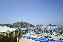
A beach in Kuşadası, with Güvercinada island seen in the background, at right.
The area has been a centre of art and culture since some of the earliest recorded history, and has been settled by many civilizations since being founded by the Leleges people in 3000 BC. Later settlers include the Aeolians in the 11th century BC and Ionians in the 9th. Originally, seamen and traders built a number of settlements along the coastline, including Neopolis.
An outpost of Ephesus in ancient Ionia, known as Pygela (Πύγελα), the area between the Büyük Menderes (Maeander) and Gediz (Hermos) rivers, the original Neopolis, is thought to have been founded on the nearby point of Yılancı Burnu. Later settlements were probably built on the hillside of Pilavtepe, in the district called Andızkulesi today. Kuşadası was a minor port frequented by vessels trading along the Aegean coast. In antiquity it was overshadowed by Ephesus, until Ephesus' harbor silted up. From the 7th century BC onwards the coast was ruled by Lydians from their capital at Sardis, then from 546 BC the Persians, and from 334 BC, along with all of Anatolia, the coast was conquered by Alexander the Great. From that point on the coastal cities in Anatolia became a centre of Hellenistic culture.
Rome and Christianity
The Roman Empire took possession of the coast in the 2nd century BC and made it their provincial capital[5] in the early years of Christianity. Saint John the Evangelist and (according to Roman Catholic sacred tradition) the Virgin Mary both came to live in the area, which in the Christian era became known as "Ania".
As Byzantine, Venetian and Genoese shippers began to trade along the coast, the port was re-founded (by the name of Scala Nova or Scala Nuova, meaning "New Port"), a garrison was placed on the island, and the town centre shifted from the hillside to the coast.
The Turkish era

Atatürk Memorial in Kuşadası

A view of the town center, with the Clock Tower seen at right.
Long afterwards, in 1834, the castle and garrison on the island were rebuilt and expanded, becoming the focus of the town. This was to such an extent that people began to refer to the whole town as Kuşadası (bird island). However, in the 19th century, trade began to decline in favor of other nearby cities with the opening of the İzmir-Selçuk-Aydın railway, which forewent Kuşadası.[6]
During the Turkish War of Independence, Kuşadası was occupied from 1919-1922, first by Italian troops between 14 May 1919 and 24 May 1922, and then by Greek troops. The Turkish forces eventually gained control of the city on September 7, 1922.[7]
Under the Republic of Turkey, the Greek population was exchanged for Turkish people as part of the population exchange between Greece and Turkey in 1922.[8] It was a district in İzmir Province until its transfer to Aydın Province in 27 June 1957.
Economy
Industry

Cruise ships at the port of Kuşadası, which is close to Ephesus and other nearby archaeological sites.
Kuşadası caters to tourists arriving by land, or from the port for cruise ship passengers heading to Ephesus. In a controversial deal in 2003, the previously public-owned port was leased to a private company and renovated to attract luxury cruise liners. The Grand Princess docks here, along with other cruise ships.
The area features several well-known local beaches, including Ladies Beach, the beach at the centrum, the beaches between the Batıhan Hotel and the Nazilli Site, the beach at Güzelçamlı, and the Dilek Peninsula National Park beach, referred to by locals as simply Milli Park.[3]
Agents sell holiday flats and villas. ٍSuch as a massive Project called Star neighborhood City, Villas Project Such as Beverly hills.
the city consider a secure investment for land and apartments as per statistics the capital appreciation up to 7%.
There are ice-cream, carpet, leather, and software vendors, as well as bookshops selling books in English, German, Russian and other languages.
Relatively old houses near the seafront, some of them converted to bars and cafes, are the remnants of old Kuşadası, which has with time become a modern, European-like town in appearance. The hills behind have been settled with large hotels and blocks of holiday flats. The building boom in the late 1980s and onwards has continued well into the hinterlands of Kuşadası.

Transportation

Davutlar Beach near Kuşadası
There is public transport within the town and to nearby locations via shuttle minibuses (dolmuş).[9] There are bus and taxi services going to the nearby airports in İzmir and in Bodrum, Muğla Province.[10] Day trips are available by boat from Kuşadası and Güzelçamlı.[11]
The city is a port of call for several cruise ships.[12]
The port is linked by a six-lane highway to İzmir's Adnan Menderes Airport.[13]
Several state roads connect the city to its surrounding districts, such as Germencik and Aydın.
There are daily ferry services to the nearby Greek island of Samos.[14]
Kuşadası's bus station is a transport hub. Coach buses connect the city to various parts of the country.[15]
Places of interest

Kaleiçi Mosque
- The city walls – There were once three gates; one remains.[16]
- Kaleiçi Mosque – Built in 1618 by Grand Vizier Öküz Kara Mehmed Pasha.[17]
- The Öküz Mehmed Pasha Caravanserai is near the docks. It was built in 1618 as a strong-room for the goods of seamen.[18]
Güvercin Adası ("Pigeon Island" in English) – The peninsula/island at the end of the bay, which has a castle and swimming beaches, including a private beach and cafe with a view back across the bay to the harbour of Kuşadası. Public beaches are located at the back of the peninsula, towards the open sea.[19]
- Kirazli – Traditional Turkish village 12 kilometres (7.5 mi) from Kuşadası.[20]
- Yılancı Burnu – A second peninsula beyond Güvercin Ada. Possibly the location of the original settlement of Neopolis. Some walls are visible. There are beaches and beach clubs here.[21]
- Several aqua-parks with wave-pools and white-water slides are located near the town.[22]
- Ladies Beach – Very close to the town center, one of the primary tourist attractions.[23]
Kadıkalesi – Venetian/Byzantine castle, 10 kilometres (6.2 mi) along the Kuşadası-Davutlar road.[24]
Panionium – 25 km (16 mi) south of Kuşadası, situated along the Davutlar-Güzelçamlı road. Once the central meeting place of the Ionian League. The ruins are in poor condition and their authenticity is disputed.[25]
Dilek Peninsula-Büyük Menderes Delta National Park – About 30 kilometres (19 mi) south of the city centre, the national park is adjacent to the town of Güzelçamlı. It has several coves, beaches, canyons, and a sink cave. It is one of the most diverse and protected national parks in Turkey.[26]
Culture
- An annual song contest has been held here. It was once won by Cem Karaca.
- The annual Fanta Gençlik Festivali (Fanta Youth Festival), hosted by the Turkish franchise of Fanta (see International availability of Fanta), travels across the country on specific dates, holding concerts at each location. On July 17, 2010, the festival hosted one of the concerts of this festival in Kuşadası.[27]
Sport
The football teams of the local sports clubs Kuşadasıspor and Kuşadası Yıldız Fenerspor, which compete in the Turkish Regional Amateur League, play their home matches in the Özer Türk Stadium.[28]
International relations
Twin towns/sister cities
Kuşadası is twinned with:
 Batumi, Georgia[29]
 Gjorče Petrov, Macedonia
 Marl, North Rhine-Westphalia, Germany
 Monterey, California, U.S.
 Sinaia, Romania
 Vathy, Greece
 Bihać, Bosnia-Herzegovina
 El-Mina, Lebanon
 Prizren, Kosovo
See also
- Blue Cruise
- Foreign purchases of real estate in Turkey
- Güzelçamlı
- Marinas in Turkey
- Turkish Riviera
References
^ "Area of regions (including lakes), km²". Regional Statistics Database. Turkish Statistical Institute. 2002. Retrieved 2013-03-05..mw-parser-output cite.citation{font-style:inherit}.mw-parser-output .citation q{quotes:"""""""'""'"}.mw-parser-output .citation .cs1-lock-free a{background:url("//upload.wikimedia.org/wikipedia/commons/thumb/6/65/Lock-green.svg/9px-Lock-green.svg.png")no-repeat;background-position:right .1em center}.mw-parser-output .citation .cs1-lock-limited a,.mw-parser-output .citation .cs1-lock-registration a{background:url("//upload.wikimedia.org/wikipedia/commons/thumb/d/d6/Lock-gray-alt-2.svg/9px-Lock-gray-alt-2.svg.png")no-repeat;background-position:right .1em center}.mw-parser-output .citation .cs1-lock-subscription a{background:url("//upload.wikimedia.org/wikipedia/commons/thumb/a/aa/Lock-red-alt-2.svg/9px-Lock-red-alt-2.svg.png")no-repeat;background-position:right .1em center}.mw-parser-output .cs1-subscription,.mw-parser-output .cs1-registration{color:#555}.mw-parser-output .cs1-subscription span,.mw-parser-output .cs1-registration span{border-bottom:1px dotted;cursor:help}.mw-parser-output .cs1-ws-icon a{background:url("//upload.wikimedia.org/wikipedia/commons/thumb/4/4c/Wikisource-logo.svg/12px-Wikisource-logo.svg.png")no-repeat;background-position:right .1em center}.mw-parser-output code.cs1-code{color:inherit;background:inherit;border:inherit;padding:inherit}.mw-parser-output .cs1-hidden-error{display:none;font-size:100%}.mw-parser-output .cs1-visible-error{font-size:100%}.mw-parser-output .cs1-maint{display:none;color:#33aa33;margin-left:0.3em}.mw-parser-output .cs1-subscription,.mw-parser-output .cs1-registration,.mw-parser-output .cs1-format{font-size:95%}.mw-parser-output .cs1-kern-left,.mw-parser-output .cs1-kern-wl-left{padding-left:0.2em}.mw-parser-output .cs1-kern-right,.mw-parser-output .cs1-kern-wl-right{padding-right:0.2em}
^ "Population of province/district centers and towns/villages by districts - 2012". Address Based Population Registration System (ABPRS) Database. Turkish Statistical Institute. Retrieved 2013-02-27.
^ ab "Kusadasi Guide".
^ artofilo.info Archived 2011-05-15 at the Wayback Machine
^ St. John - History
^ Encyclopædia Britannica Eleventh Edition
^ "Kuşadası'nda Kurtuluş Coşkusu" (in Turkish). Haberkapısı. 7 September 2010. Archived from the original on 3 March 2016.
^ "Twice a Stranger: The Mass Expulsions That Forged Modern Greece and Turkey".
^ "Public bus from Kusadasi to Ephesus". ShoreBee.
^ "Day 5 - Izmir to Kuşadası".
^ "Guzelcamli boat trip". TripAdvisor.
^ "The cruise port of Kusadasi". ShoreBee.
^ "Otoyol O-31 - İzmir-Aydın Otoyolu". Motorways - Exit Lists.
^ "Ferry to Samos". Meander Travel.
^ "How to get to and around Kuşadası, Turkey". My Favourite Planet.
^ "Kuşadası: From past to present". Kuşadası Belediyesi. Archived from the original on 2015-07-25.
^ "Kaleiçi Mosque". Wikimapia.
^ "Kuşadası – Okuz Mehmed Pasha Caravanserai". Rental Car Kuşadası.
^ "8 Top-Rated Tourist Attractions in Kuşadası". PlanetWare.
^ "Kirazli Hotels, Hostels & Accommodations". Lonely Planet.
^ "Cape Yılancı". Lonely Planet.
^ "Waterparks in Kuşadası". Kuşadası Guide.
^ "Kadınlar Denizi". Lonely Planet.
^ "Archaeological Tours - Kadikalesi Anaia Tour with an Expert Archaeologist". Meander Travel.
^ "Panionium (Site)". Perseus Digital Library.
^ "Dilek National Park (Milli Park)". Viator.
^ "2010 Fanta Gençlik Festivali Takvimi". Archived from the original on 2016-03-04.
^ "Kuşadası Özer Türk Stadı" (in Turkish). Amatör Futbol. Retrieved 2015-10-02.
^ "Batumi – Twin Towns & Sister Cities". Batumi City Hall. Archived from the original on 2012-05-04. Retrieved 2013-08-10.
External links
| Wikivoyage has a travel guide for Kusadasi. |
| Wikimedia Commons has media related to Kuşadası. |
- Kusadasi Information
- Kusadasi Guide
Kuşadası in Aydın Province of Turkey | |||||||||||||||||||||||||||
|---|---|---|---|---|---|---|---|---|---|---|---|---|---|---|---|---|---|---|---|---|---|---|---|---|---|---|---|
| Districts |
|  | |||||||||||||||||||||||||
||
Metropolitan municipalities are bolded. | |||||||||||||||||||||||||||


