Butare
| Butare | |
|---|---|
 The National Museum of Rwanda at Butare | |
 Butare Location in Rwanda | |
| Coordinates: 2°36′S 29°45′E / 2.600°S 29.750°E / -2.600; 29.750 | |
| Country | |
| Admin. division | Southern Province |
| Population (2015) | |
| • Total | 89,600 |
Butare (Kinyarwanda: [butɑ́ɾe]) is a city (population: 77,000 as of August 2002) in the Southern Province of Rwanda and capital of Huye district. It was the capital of the former Butare Province, Rwanda, that was dissolved on January 1, 2006.[citation needed] It was established in the 1920s as Astrida and served as the colonial capital of Rwanda.[1]
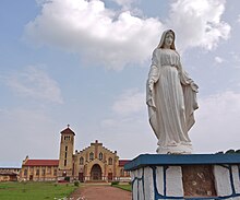
The large Christian Cathedral.

Main street.
From 2006, some sources refer to the city as Huye, after the surrounding district, but most Rwandans continue to use the name Butare.[citation needed]
It has a campus of the University of Rwanda, the Ruhande Arboretum, and a cathedral. It is also home to the Stade Huye (Butare Stadium).
Contents
1 History
2 Education
3 Transportation
4 References
History
The Belgian colonial rulers established it in the 1920s and named the city Astrida, in honor of Queen Astrid of Belgium,[1] and the name was changed after Rwanda became a republic in 1962. The first Catholic mission in 1900 in the country was only a few kilometers from the town center, at Save Hill.
Education
Butare used to be home to the National University of Rwanda which is now part of University of Rwanda. Due to the large number of university students and student-centered activities in the city, Butare is often regarded as a university city. In addition it also held the prestigious Nyakibanda Seminary and the Rwandan National Institute of Scientific Research.
The city of Butare has long been regarded as the intellectual capital of the country, while Kigali holds most political power.
The Groupe Scolaire Officiel de Butare is the largest secondary school in Rwanda.[2]
Other secondary schools include:[1]
École secondaire des parents (CEFOTEC)- École autonome de Butare
- École agricole et veterinaire de Kabutare
- École sociale de Karubanda
- Petit Seminaire de Butare
- Petit Seminaire Baptiste
The National Museum of Rwanda was built in the early 1990s and is a good source of information on the cultural history of the country and the region. It is often referred to in tourist brochures as the finest museum in East Africa.[citation needed]
Coordinates: 2°36′S 29°45′E / 2.600°S 29.750°E / -2.600; 29.750
Transportation
The city is served by Butare Airport, a small civilian airport, administered by the Rwanda Civil Aviation Authority.
References
| Wikivoyage has a travel guide for Huye. |
^ abc "Butare, a university town." National University of Rwanda. 22 January 2001. Retrieved on 11 November 2018.
^ Tanganika, Frank. "Rwanda: Significant Developments in Schools." AllAfrica, 2 September 2010. Retrieved on September 18, 2010. "I recently visited Lycée de Kigali, the second largest secondary school in the country after Groupe Scolaire, Butare, and I was impressed by the...."

