Karnali Pradesh
Karnali Pradesh कर्णाली प्रदेश | |
|---|---|
Province | |
 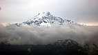 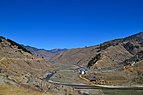  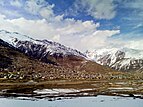 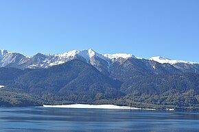 From top going clockwise:Phoksundo lake, Sinja Valley, Simikot, Rara lake, Karnali Bridge and Kanjiroba | |
 Location of Karnali Pradesh | |
 Districts of Karnali Pradesh | |
| Country | |
| Formation | 20 September 2015 |
| Capital | Birendranagar |
| Largest city | Birendranagar |
| Districts | 10 |
| Government | |
| • Body | Government of Karnali Pradesh |
| • Governor | Durga Keshar Khanal |
| • Chief Minister | Mahendra Bahadur Shahi (NCP) |
| • High Court | Surkhet High Court |
| • Provincial Assembly | Unicameral (40 seats) |
| • Parliamentary constituency | 12 |
| Area | |
| • Total | 24,453 km2 (9,441 sq mi) |
| Area rank | 1st |
| Population (2011) | |
| • Total | 1,570,418 |
| • Rank | 7th |
| • Density | 64/km2 (170/sq mi) |
| • Density rank | 7th |
| Demonym(s) | Karnali/Karnalese |
| Time zone | UTC+5:45 (NST) |
| Geocode | NP-SI |
| Main Official Language | Nepali (96.47%) |
| Other Official Language(s) | 1. Magar (1.1%) 2. Tamang (0.9%) |
| HDI | 0.469 (low) |
| Literacy | 62.77% |
| Sex ratio | 95.78 ♂ /100 ♀ (2011) |
| Website | www.karnali.gov.np |
Karnali Pradesh (Nepali: कर्णाली प्रदेश) is one of the seven federal provinces of Nepal formed by a new constitution which was adopted on 20 September 2015.[1] The total area of the province is 24,453 square kilometres (9,441 sq mi). According to the 2011 Nepal census, the population of the province was 1,570,418. On 1 January 2016, the estimated population was 1,701,800.[2]
Initially known as Province No. 6, the newly elected Provincial Assembly adopted Karnali Pradesh as the permanent name for the province in February 2018. It borders the Tibet Autonomous Region of China to the north, Gandaki Pradesh to the east, Sudurpashchim Pradesh to the west, and Province No. 5 to the south.[3]Birendranagar was declared the capital city of the province in January 2018.[4]
Contents
1 History
2 Geography
3 Government and administration
4 Administrative subdivisions
5 See also
6 References
History
Karnali is an old civilization of Nepal and it is connected with Karnali River [5] The archaeological sites found in Jumla, Surkhet and Dailekh refers that this area was part of Khasa kingdom which was established during 11th century. The capital of the Khas Kingdom was Sinja. The kingdom was expanded to a great extent in l3th and 14th century. This kingdom was expanded to Garhwal in the west, Mansarowar and Guge regions of Tibet in the north, Gorkha-Nuwakot regions in the east and with Kapilvastu with large areas Terai in the South. After late 14th century the Khas empire collapsed and divided into Baise Rajya (22 principalities) in Karnali-Bheri region.[6]
Before unification of modern Nepal, the part of Karnali (from Karnali River to Bheri River) was an Sanghiya Baise Rajya (United 22 principalities state). The Baise were sovereign, but intermittently allied among themselves until they were annexed during the unification of modern Nepal from 1744 to 1810.
Geography
Karnali is the largest province of Nepal with an area of 24,453 km2 (9,441 sq mi), but the population of the province is very low. The population of the province is 1,701,800, which is least in ranking.
The province is surrounded by Gandaki province in east, Province No. 5 in south-east and south, Province No. 7 in west and Tibet Autonomous Region of China in north.
The province has occupied higher mountains land of north and mid-hills of Nepal. It contains Kubi Gangri, Changla and Kanjiroba mountains in north. The Shey Phoksundo National Park with Phoksundo lake is the largest national park of Nepal and Rara lake is the largest lake of Nepal which are located in Karnali Pradesh. Karnali River is the biggest river of the province which is thought to be longest river of Nepal. Seti River and Bheri River are tributaries of Karnali.
Government and administration
The Governor acts as the head of the province while the Chief Minister is the head of the provincial government. The Chief Judge of the Surkhet High Court is the head of the judiciary.[7] The present Governor, Chief Minister and Chief Judge are Durga Keshar Khanal (governor), Mahendra Bahadur Shahi (chief minister) and Hari Kumar Pokharel.[8][9] The province has 40 provincial assembly constituencies and 12 House of Representative constituencies.[10]
Karnali has a unicameral legislature, like all of the other provinces in Nepal. The term length of provincial assembly is five years. The Provincial Assembly of Karnali is temporarily housed at the Irrigation Division Office in Birendranagar.[11]
Administrative subdivisions
Karnali is divided into ten districts, which are listed below. A district is administrated by the head of the District Coordination Committee and the District Administration Officer. The districts are further dived to municipalities or rural municipalities. There are 25 municipalities and 54 rural municipalities in the province[12]
- Dailekh District
- Dolpa District
- Humla District
- Jajarkot District
- Jumla District
- Kalikot District
- Mugu District
- Salyan District
- Surkhet District
- Western Rukum District
Largest cities or towns in Karnali Central Bureau of Statistics [1] | |||||||||
|---|---|---|---|---|---|---|---|---|---|
| Rank | District | Pop. | Rank | District | Pop. | ||||
 Birendranagar | 1 | Birendranagar | Surkhet | 100,458 | 11 | Musikot | Rukum West | 32,939 | |
| 2 | Gurbhakot | Surkhet | 43,765 | 12 | Panchapuri | Surkhet | 32,231 | ||
| 3 | Dullu | Dailekh | 41,540 | 13 | Lekbeshi | Surkhet | 30,295 | ||
| 4 | Bheriganga | Surkhet | 41,407 | 14 | Aathabis | Dailekh | 29,227 | ||
| 5 | Bangad Kupinde | Salyan | 36,052 | 15 | Chaurjahari | Rukum West | 27,438 | ||
| 6 | Chhedagad | Jajarkot | 35,295 | 16 | Narayan | Dailekh | 27,037 | ||
| 7 | Bagchaur | Salyan | 34,118 | 17 | Chamunda Bindrasaini | Dailekh | 26,149 | ||
| 8 | Shaarda | Salyan | 33,730 | 18 | Nalgad | Jajarkot | 25,597 | ||
| 9 | Aathbis Kot | Rukum West | 33,601 | 19 | Khandachakra | Kalikot | 20,288 | ||
| 10 | Bheri | Jajarkot | 33,515 | 20 | Chhayanath Rara | Mugu | 20,078 | ||
See also
- List of provinces of Nepal
- List of districts of Nepal
References
^ "Nepal Provinces". statoids.com. Retrieved 2016-03-21..mw-parser-output cite.citation{font-style:inherit}.mw-parser-output q{quotes:"""""""'""'"}.mw-parser-output code.cs1-code{color:inherit;background:inherit;border:inherit;padding:inherit}.mw-parser-output .cs1-lock-free a{background:url("//upload.wikimedia.org/wikipedia/commons/thumb/6/65/Lock-green.svg/9px-Lock-green.svg.png")no-repeat;background-position:right .1em center}.mw-parser-output .cs1-lock-limited a,.mw-parser-output .cs1-lock-registration a{background:url("//upload.wikimedia.org/wikipedia/commons/thumb/d/d6/Lock-gray-alt-2.svg/9px-Lock-gray-alt-2.svg.png")no-repeat;background-position:right .1em center}.mw-parser-output .cs1-lock-subscription a{background:url("//upload.wikimedia.org/wikipedia/commons/thumb/a/aa/Lock-red-alt-2.svg/9px-Lock-red-alt-2.svg.png")no-repeat;background-position:right .1em center}.mw-parser-output .cs1-subscription,.mw-parser-output .cs1-registration{color:#555}.mw-parser-output .cs1-subscription span,.mw-parser-output .cs1-registration span{border-bottom:1px dotted;cursor:help}.mw-parser-output .cs1-hidden-error{display:none;font-size:100%}.mw-parser-output .cs1-visible-error{font-size:100%}.mw-parser-output .cs1-subscription,.mw-parser-output .cs1-registration,.mw-parser-output .cs1-format{font-size:95%}.mw-parser-output .cs1-kern-left,.mw-parser-output .cs1-kern-wl-left{padding-left:0.2em}.mw-parser-output .cs1-kern-right,.mw-parser-output .cs1-kern-wl-right{padding-right:0.2em}
^ "Karnali Province in Nepal population". www.citypopulation.de. 7 October 2017. Retrieved 25 February 2018.
^ "Prov 6 named as Karnali, permanent capital in Birendranagar". www.myrepublica.com. 24 February 2018. Retrieved 24 February 2018.
^ "Government finalises provinces' governors and temporary headquarters". nepalekhabar.com. 17 January 2018. Retrieved 19 January 2018.
^ "कर्णाली प्रदेश एक चिनारी". www.ocmcm.karnali.gov.np. The office of chief minister and cabinet of Karnali Pradesh. Retrieved 9 July 2018.
^ "Nepal in the Medieval Period". www.telegraphnepal.com. 2 February 2015. Retrieved 26 February 2018.
^ "High Courts get their chief judges". Retrieved 2018-04-27.
^ "Mahendra Bahadur Shahi set to be Province 6 CM | Setopati - Nepal's Digital Newspaper". setopati.net. Retrieved 2018-04-28.
^ "President of Nepal administers oath to Chiefs of seven provinces | DD News". ddnews.gov.in. Retrieved 2018-04-27.
^ "CDC creates 495 constituencies". The Himalayan Times. 2017-08-31. Retrieved 2018-04-27.
^ "First Provincial Assembly meeting begins in 4 provinces". Retrieved 2018-04-27.
^ "स्थानिय तह". 103.69.124.141. Retrieved 2018-04-27.
Places adjacent to Karnali Pradesh | ||||||||||
|---|---|---|---|---|---|---|---|---|---|---|
| ||||||||||
Provinces of Nepal | ||
|---|---|---|
|  | |
Coordinates: 29°30′N 82°25′E / 29.500°N 82.417°E / 29.500; 82.417
This Nepalese location article is a stub. You can help Wikipedia by expanding it. |


