Chemins de fer de l'Ouest
 | |
| Locale | Normandy, Paris and Brittany |
|---|---|
| Dates of operation | 1855–1909 |
| Track gauge | 1,435 mm (4 ft 8 1⁄2 in) standard gauge |
| Headquarters | Paris |
The Compagnie des chemins de fer de l'Ouest (CF de l'Ouest), often referred to simply as L'Ouest or Ouest, was an early French railway company.
Contents
1 History
1.1 Birth of the company
1.1.1 Paris à Saint-Germain
1.1.2 The old Ouest
1.1.3 Paris à Rouen
1.2 Expansion
1.3 Accidents
1.4 Paris stations
1.5 La Ligne d'Auteuil
1.6 Line openings
2 Architecture
2.1 A sense of identity
2.2 Station photos
3 Locomotives
3.1 Heilmann locomotives
4 References
4.1 Sources
5 External links
History
Birth of the company
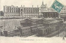
St Germain en Laye train station. The station is now underground.
The Compagnie de l'Ouest was created in 1855 by the merger of various small railway companies active in the western outskirts of Paris, in Normandy and in Brittany. These were:[1]
- Paris à Saint-Germain
- Paris à Rouen
- Rouen au Havre
Dieppe à Fécamp
- Paris à Caen et à Cherbourg
- the old Ouest (two lines from Paris to Versailles and Paris–Rennes)
Paris à Saint-Germain
The Ouest's oldest line (still open to this day) is the line from Paris to Le Pecq, built by Émile Péreire's Compagnie du Chemin de fer de Paris à Saint-Germain and inaugurated on 24 August 1837 by Marie-Amélie, wife of King Louis-Philippe. The line was 19 km (12 mi) long and the trip took 30 minutes. Initially greeted with fear and lack of interest, the railway was a success that paved the way for other new railways, for instance to Rouen. In 1847, the line to Le Pecq was extended to Saint-Germain-en-Laye. The section between Saint-Germain-en-Laye and Nanterre – Université is now part of the RER line A. The section between Paris Saint-Lazare and Nanterre is part of the main lines to Rouen and Caen.
The old Ouest
While the line to Saint-Germain-en-Laye was being built, a line to Versailles, another popular Sunday destination, was projected. Two lines were built, one from Gare Saint-Lazare to the terminus Versailles-Rive-Droite, the other from Gare Montparnasse (Barrière du Maine) to the terminus Versailles-Rive-Gauche. James Mayer de Rothschild in conjunction with the Chemin de Fer de Versailles-rive-Droite, created in 1837, were given the concession to operate the lines. The line to Versailles-Rive-Droite, opened on 4 August 1839 and still in use today as Transilien line L, is 19 km (12 mi) long, branching off the line to Saint-Germain at Asnières-sur-Seine. The line to Versailles-Rive-Gauche is also still in use today. The part between Montparnasse and Viroflay is used by trains from Paris to Chartres and Brittany as well as Transilien line N. The part between Viroflay and Versailles is used by RER C local trains.
Paris à Rouen
Two lines to Rouen in Normandy were projected: one passing through La Garenne-Colombes and following the left Seine bank from Poissy, the other passing through Pontoise and following the high plateaux on the right Seine bank. Due to the lack of confidence in the second project, the first one was granted and the concession given to Charles Laffitte and Edouard Blount. Construction began in 1841 under the orders of engineer Joseph Locke and with the help of British workers. Inauguration of the line was on 9 May 1843. It was an immediate success, so much so that issues with the Chemin de Fer de Saint-Germain with platform allocation at Gare Saint-Lazare occurred.
Expansion
The Imperial Government imposed the construction of several lines:
Argentan - Granville
Rennes - Brest
Rennes - Saint-Malo
Rennes - Redon
Le Mans - Angers
Serquigny - Rouen
Lisieux - Honfleur
Mézidon-Canon - Le Mans
The Government also imposed several secondary lines.
The network was rapidly expanded:[2]
To better use the Rive-Droite line, a 15 km (9 mi) long branch was built from Saint-Cloud to Saint-Nom-la-Bretèche at the cost of the French State. The line was declared of public utility in 1880 and the Chemins de fer de l'Ouest opened the line to l'Étang-la-Ville in 1884. Passenger services were extended to Saint-Germain Grande-Ceinture in 1889, services were then reported back to Saint-Nom-la-Bretèche in 1894 when passenger services on the Chemin de fer de Grande Ceinture were stopped.
A second line from Saint-Lazare to Mantes-la-Jolie was opened in 1892, following the right Seine bank. The new line started at Argenteuil, and passed Conflans-Sainte-Honorine, Triel and Meulan.[3]
Because of the company's bad financial situation due to the region it served (agricultural for the most part), the law of 13 July 1908 saw the integration of the Companie des Chemins de fer de l'Ouest into the Chemins de fer de l'État on 1 January 1909.
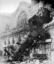
Accidents
Train goes too far at Gare Montparnasse, Paris
- On a Sunday in May 1842 one of the worst accidents in French railway history happened near Meudon: 164 victims; the 55 dead were burnt alive (see Versailles train crash). After this incident the company no longer locked doors on passenger coaches.
Montparnasse derailment: On 22 October 1895 an express train originating from Granville traversed Montparnasse station, ploughed into the buffers, wrecked the station building's front wall and dropped to the ground on the street below. The only fatality was the wife of a newspaper vendor, filling in for her husband (who had gone to get the evening newspapers), who was killed by falling masonry from the wall.- In 1881 there were 2064 railway related accidents: 185 derailings, 190 collisions, 692 accidents on the line. 512 passengers died in these accidents, 1/10 of those who died in accidents on stagecoaches.
- Lists of rail accidents
Paris stations
L'Ouest built several stations within Paris; the two main terminals St Lazare and Montparnasse as well as Pont Cardinet at the beginning of the line to Auteuil.
In 1851 the Ouest's Paris terminus, the Gare Saint-Lazare, was enlarged to comprise six groups for each main destination served:
- Group I & II: Versailles
- Group III: Auteuil
- Group IV: Argenteuil
- Group V: Saint-Germain-en-Laye
- Group VI: Rouen, Le Havre & Dieppe (the line to Caen served by this group was not opened until 1855)
La Ligne d'Auteuil
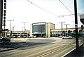
 Courcelles-Levallois station now part of Paris' RER C line but originally part of La Ligne d'Auteuil. |
Line openings
Date | Section | Length (km) |
| 26 August 1837 | Paris St Lazare - Le Pecq | 19 |
| 2 August 1839 | Asnières - Versailles Rive Droite | 18 |
| 10 September 1840 | Paris Barrière du Maine - Versailles Rive Gauche | 17 |
| 9 May 1843 | Paris St Lazare - Rouen Saint-Sever | |
| 22 March 1847 | Rouen Saint-Sever - Le Havre | 94 |
| 14 August 1847 | Le Pecq - Saint-Germain-en-Laye | 3 |
| 1 August 1848 | Malaunay - Dieppe | 50 |
| 12 July 1849 | Viroflay - Chartres | 73 |
| 28 April 1851 | Asnières - Argenteuil | 4 |
| 20 July 1852 | Viroflay - Porchefontaine | 1 |
| 7 September 1852 | Chartres - La Loupe | 36 |
| 16 February 1854 | La Loupe - Nogent-le-Rotrou | 25 |
| 2 May 1854 | Les Batignoles - Auteuil | 7 |
| 1 June 1854 | Nogent-le-Rotrou - Le Mans | 63 |
| 1 July 1855 | Mantes-la-Jolie - Lisieux | 133 |
| 14 August 1855 | Le Mans - Laval | 89 |
| 29 December 1855 | Lisieux - Mondeville (near Caen) | 49 |
| 25 February 1856 | Beuzeville - Fécamp | 20 |
| 15 March 1856 | Le Mans - Alençon | 52 |
| 1 May 1857 | Laval - Rennes | 73 |
| 1 May 1857 | Mondeville-Caen | 2 |
| 1 February 1858 | Alençon - Argentan | 43 |
| 1 July 1858 | Lisieux - Pont-l'Évêque | 18 |
| 17 July 1858 | Caen - Cherbourg | 133 |
| 20 November 1858 | Through Fécamp | 2 |
| 1 February 1859 | Argentan - Mézidon-Canon | 43 |
| 1 November 1859 | Falaise | 7 |
| 1 May 1860 | Lison - St-Lô | 19 |
| 7 July 1862 | Pont-l'Évêque - Honfleur | 25 |
| 23 March 1863 | Le Mans - Sablé | 48 |
| 7 July 1863 | Pont-L'Évêque - Trouville-Deauville | 10 |
| 7 December 1863 | Sablé - Angers | 47 |
| 15 June 1864 | Saint-Cyr-l'École - Dreux | 59 |
| 27 June 1864 | Rennes - Saint-Malo | 81 |
| 24 July 1865 | Serquigny - Oissel | 57 |
| 2 July 1866 | Argentan - flers | 43 |
| 1 October 1866 | Dreux - L'Aigle | 60 |
| 5 November 1866 | L'Aigle - Conches | 40 |
| 6 November 1866 | Laval - Mayenne | 20 |
| 23 April 1867 | Saint-Pierre-du-Vauvray - Louviers | 7 |
| 5 August 1867 | L'Aigle - Surdon | 41 |
| 23 August 1867 | Glos-Montfort - Pont-Audemer | 17 |
| 16 September 1867 | Flers - Vire | 29 |
| 4 October 1867 | Pontoise - Gisors | 40 |
| 9 November 1868 | Flers - Berjou-Pont-d'Ouilly | 19 |
| 28 December 1868 | Gisors - Pont-de-l'Arche | 54 |
| 15 July 1869 | Gisors - Vernonnet | 36 |
| 14 February 1870 | Rouen - Le Petit-Quevilly | 3 |
| 15 May 1870 | Vernonnet - Vernon | 2 |
| 3 July 1870 | Vire - Granville | 57 |
| 25 January 1872 | Fougères - Saint-Brice-en-Coglès | 18 |
| 10 May 1872 | Louviers - Évreux | 26 |
| 10 October 1872 | Saint-Brice-en-Coglès - Moidrey | 29 |
| 1 May 1873 | Vernon - Pacy-sur-Eure | 19 |
| 6 May 1873 | Alençon - Condé-sur-Huisne | 66 |
| 10 May 1873 | Caen - Berjou-Pont-d'Ouilly | 46 |
| 2 June 1873 | Lisieux - Orbec | 18 |
| 2 August 1873 | Chartres - Dreux | 42 |
| 22 December 1873 | Neufchâtel-en-Bray - Dieppe | 34 |
| 15 April 1874 | Falaise - Berjou-Pont-d'Ouilly | 28 |
| 18 May 1874 | Flers - Domfront | 21 |
| 21 September 1874 | Domfront - Mayenne | 38 |
| 15 August 1875 | Louviers - Caudebec-lès-Elbeuf | 18 |
| 14 January 1876 | Caudebec-lès-Elbeuf - Elbeuf | 1 |
| 1 July 1876 | Motteville - Clères | 22 |
| 1 October 1878 | Harfleur - Montivilliers | 5 |
| 30 December 1878 | Saint-Lô - Coutances | 29 |
| 30 December 1878 | Avranches - Dol-de-Bretagne | 43 |
| 15 June 1879 | Mézidon - Dives-sur-Mer | 28 |
| 29 December 1879 | Coutances - Lamballe | 112 |
| 11 June 1880 | Motteville - Cany | 38 |
| 19 September 1880 | Alençon - Pré-en-Pail | 27 |
| 22 November 1880 | Sainte-Gauburge - Gacé | 17 |
| 3 January 1881 | Mamers - Bellême | 20 |
| 11 April 1881 | Redon - Châteaubriant | 45 |
| 26 May 1881 | La Ferté-Macé - Couterne | 15 |
| 26 May 1881 | Pré-en-Pail - Domfront | 41 |
| 20 June 1881 | Bréauté-Beuzeville - Bolbec | 5 |
| 20 June 1881 | Barentin - Duclair | 14 |
| 20 June 1881 | Through Courbevoie | 2 |
| 27 June 1881 | Questembert - Ploërmel | 34 |
| 9 October 1881 | Gacé - Ticheville-Le Sap | 13 |
| 16 October 1881 | Bellême - Mortagne | 18 |
| 23 October 1881 | Pré-en-Pail - La Selle-en-Luitré | 86 |
| 13 November 1881 | Plouaret - Lannion | 16 |
| 22 November 1881 | Échauffour - Bernay | 46 |
| 28 December 1881 | Châteaubriant - Vitré | 98 |
| 28 December 1881 | Mortagne-au-Perche - L'Aigle | 37 |
| 29 December 1881 | Mortagne-au-Perche - Sainte-Gauburge | 35 |
| 24 July 1882 | Auray - Quiberon | 26 |
| 31 July 1882 | Duclair - Caudebec-en-Caux | 15 |
| 31 July 1882 | Bolbec - Lillebonne | 9 |
| 4 September 1882 | Achères - Versailles-Matelots (GC) | 23 |
| 18 September 1882 | La Trinité-de-Réville - Orbec | 13 |
| 18 September 1882 | Dives - Beuzeval (Houlgate) | 2 |
| 18 September 1882 | Trouville-Deauville - Villers-sur-Mer | 9 |
| 8 January 1883 | Gare de Rouen Rue Verte - Elbeuf | 23 |
| 30 June 1883 | Through Rouen (Gare de Rouen Saint-Sever - Gare de Rouen Rue Verte) | 2 |
| 22 October 1883 | Pontorson - Mont-Saint-Michel | 1 |
| 27 January 1884 | Sottevast - Coutances | 72 |
| 6 April 1884 | Ploërmel - La Brohinière | 41 |
| 6 April 1884 | Miniac - La Gouesnière | 12 |
| 5 May 1884 | Saint-Cloud - L'Etang-la-Ville | 15 |
| 26 May 1884 | Sablé - Sillé-le-Guillaume | 44 |
| 20 July 1884 | Beuzeval (Houlgate) - Villers-sur-Mer | 9 |
| 18 May 1885 | Châteaubriant - Saint-Nazaire | 72 |
| 18 May 1885 | Saint-Mars-la-Jaille - Nantes | 49 |
| 22 August 1885 | Eu - Dieppe | 37 |
| 27 July 1886 | Verneuil-sur-Avre - Damville | 28 |
| 22 August 1886 | Caen - Aunay-Saint-Georges | 32 |
| 18 April 1887 | Saint-Brieuc - Légué | 6 |
| 10 July 1887 | Dinan - Dinard | 18 |
| 21 August 1887 | Dreux - Maintenon | 25 |
| 18 December 1887 | Mortain - Vire | 30 |
| 20 December 1887 | Saint-Aubin-du-Vieil-Évreux - Évreux | 7 |
| 2 January 1888 | Évreux - Le Neubourg | 24 |
| 1 July 1888 | Le Neubourg - Glos-Montfort | 24 |
| 1 July 1888 | Saint-Aubin-du-Vieil-Évreux - Damville | 20 |
| 2 December 1888 | Pouancé - Laval | 58 |
| 1 May 1889 | Javel - Puteaux | 12 |
| 8 June 1889 | Pont-Audemer - Quetteville | 16 |
| 16 June 1889 | Pontaubault - Mortain-Le Neufbourg | 39 |
| 11 July 1889 | Saint-Georges-Motel - Prey | 24 |
| 11 November 1889 | Verneuil-sur-Avre- La Loupe | 39 |
| 1 June 1891 | Aunay-Saint-Georges - Vire | 40 |
| 3 April 1892 | Auneau - Maintenon | 25 |
| 3 April 1892 | Saint-Lô - Guilberville | 25 |
| 1 June 1892 | Argenteuil - Mantes | 52 |
| 12 November 1893 | Domfront - Romagny | 27 |
| 8 July 1894 | Carentan - La Haye-du-Puits | 22 |
| 8 July 1894 | Fougères - Saint-Hilaire-du-Harcouët | 36 |
| 22 June 1895 | Les Ifs - Étretat | 15 |
| 31 May 1896 | Saint-Pierre-du-Vauvray - Les Andelys | 17 |
| 26 July 1896 | La Brohinière - Dinan | 38 |
| 9 August 1896 | Châteaubriant - Messac | 41 |
| 14 August 1896 | Rolleville - Montivilliers | 6 |
| 24 December 1896 | Rolleville - Les Ifs | 22 |
| 20 February 1898 | Dieppe - Saint-Vaast-Bosville | 37 |
| 12 April 1900 | Courcelles-Levallois - Champ de Mars | 4 |
| 12 April 1900 | Champ de Mars - Invalides | 4 |
| 30 August 1900 | Épône - Plaisir-Grignon | 18 |
| 25 October 1900 | Cany - Fécamp | 24 |
| 1 July 1901 | Issy-les-Moulineaux - Meudon-Val-Fleury | 4 |
| 19 August 1901 | Blain - La Chapelle-sur-Erdre | 29 |
| 31 May 1902 | Meudon-Val-Fleury - Viroflay Rive Gauche | 6 |
| 3 August 1902 | Coutances - Regnéville-sur-Mer | 8 |
| 5 April 1903 | Messac - Ploërmel | 51 |
| 13 July 1907 | Charleval - Vascœuil | 10 |
Architecture
A sense of identity
As with many other railway companies, the Ouest adopted its own architectural style. Stations in large cities such as Le Havre, Lisieux, Deauville and Paris are unique. More modest halts were graced with 'type' building, which are called 'type Ouest', the best-preserved examples can be found in Dives-sur-Mer and Houlgate.
According to the size of the town or village close to the proposed site for the station, a station of a certain size was built. There are three generic types of station buildings; the BV3, BV5 and BV7. BV stands for Bâtiment Voyageur (station building) and the number, the number of doors accessible. The larger the town, the larger the station building.
As well as stations, infrastructure was also in mind when saving money so the Ouest created a level crossing guard house template (see below).
Station photos

Paris St Lazare station

Rouen Rue Verte station
Caen station

Blonville-Bénèrville station

Houlgate station
Pont L'Evèque station

Trouville-Deauville station

Villers-sur-Mer station

A typical Ouest level crossing guard house


Locomotives

CF de l'État 2-2-2T No 12-010, formerly CF de l'Ouest No 0134. The locomotive was built in 1844.
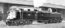
Heilmann locomotive No. 8001
Heilmann locomotives
In 1893, Jean Jacques Heilmann built a steam-electric locomotive of Do Do wheel arrangement, which was trialled on the CF de l'Ouest. Named La Fusée Electrique (English: The Electric Rocket), it was successful enough that two larger locomotives were constructed in 1897. These were numbered 8001 and 8002. Although considered successful, the design was not proceeded with and all three locomotives were dismantled.
References
^ Joanne, Adolphe (1859). Atlas historique et statistique des chemins de fer français (in French). Paris: L. Hachette. pp. 21–22..mw-parser-output cite.citation{font-style:inherit}.mw-parser-output .citation q{quotes:"""""""'""'"}.mw-parser-output .citation .cs1-lock-free a{background:url("//upload.wikimedia.org/wikipedia/commons/thumb/6/65/Lock-green.svg/9px-Lock-green.svg.png")no-repeat;background-position:right .1em center}.mw-parser-output .citation .cs1-lock-limited a,.mw-parser-output .citation .cs1-lock-registration a{background:url("//upload.wikimedia.org/wikipedia/commons/thumb/d/d6/Lock-gray-alt-2.svg/9px-Lock-gray-alt-2.svg.png")no-repeat;background-position:right .1em center}.mw-parser-output .citation .cs1-lock-subscription a{background:url("//upload.wikimedia.org/wikipedia/commons/thumb/a/aa/Lock-red-alt-2.svg/9px-Lock-red-alt-2.svg.png")no-repeat;background-position:right .1em center}.mw-parser-output .cs1-subscription,.mw-parser-output .cs1-registration{color:#555}.mw-parser-output .cs1-subscription span,.mw-parser-output .cs1-registration span{border-bottom:1px dotted;cursor:help}.mw-parser-output .cs1-ws-icon a{background:url("//upload.wikimedia.org/wikipedia/commons/thumb/4/4c/Wikisource-logo.svg/12px-Wikisource-logo.svg.png")no-repeat;background-position:right .1em center}.mw-parser-output code.cs1-code{color:inherit;background:inherit;border:inherit;padding:inherit}.mw-parser-output .cs1-hidden-error{display:none;font-size:100%}.mw-parser-output .cs1-visible-error{font-size:100%}.mw-parser-output .cs1-maint{display:none;color:#33aa33;margin-left:0.3em}.mw-parser-output .cs1-subscription,.mw-parser-output .cs1-registration,.mw-parser-output .cs1-format{font-size:95%}.mw-parser-output .cs1-kern-left,.mw-parser-output .cs1-kern-wl-left{padding-left:0.2em}.mw-parser-output .cs1-kern-right,.mw-parser-output .cs1-kern-wl-right{padding-right:0.2em}
^ Direction Générale des Ponts et Chaussées et des Chemins de Fer (1869). Statistique centrale des chemins de fer. Chemins de fer français. Situation au 31 décembre 1869 (in French). Paris: Ministère des Travaux Publics. pp. 146–160.
^ History of Triel
Sources
(in French) Histoire du réseau ferroviaire français, 1996, Editions de l'Ormet / Imprimerie Bayeusienne Graphique.
ISBN 2-906575-22-4
(in French) Le tour du Calvados en 80 cartes, 1996, Direction Départementale de l'Equipement (Calvados).
(in French) Paris et l'Île de France - Tome 1: Les réseaux Est, Nord et Saint-Lazare, 2002, Le Train. ISSN 1267-5008
(in French) Electrification des lignes Paris-Caen-Cherbourg et Paris-Trouville-Deauville, 1996, Conseil Régional de Basse Normandie (Rémy Desquesnes).
External links
| Wikimedia Commons has media related to Compagnie des chemins de fer de l'Ouest. |


