Eder
| Eder Eder Edder | |
|---|---|
 The Eder in Edersee when the lake dried out in 2003 | |
 Map of the Eder, its tributaries and water catchment area | |
| Etymology | Adrana-Aderna-Adarna-Adrina-Edder-Eder |
| Location | |
| Country | Germany |
| States | North Rhine-Westphalia-Hesse |
| Physical characteristics | |
| Source | |
| - location | Ederkopf |
| - elevation | 634 m (2,080 ft) |
| Mouth | |
- location | Edermünde |
- elevation | 142 m (466 ft) |
| Length | 176.1 km (109.4 mi) [1] |
| Basin size | 3,362 km2 (1,298 sq mi) [1] |
| Discharge | |
| - average | 23.8 m3/s (840 cu ft/s) |
| Basin features | |
| Progression | Fulda→ Weser→ North Sea |
| Tributaries | |
| - left | main: Odeborg, Orke, Ems. see also below |
| - right | main: Nuhne, Wesebach, Schwalm. see also below |
The Eder [ˈeːdɐ] is a 177-kilometre (110 mi) long major river in Germany that begins in eastern North Rhine-Westphalia and passes in to Hesse, where it confluences with the River Fulda.
Contents
1 History
2 Gold in the Eder
3 Course
4 Edersee Dam
5 Destruction of the Eder dam
6 Tributaries of the Eder
7 References
History
The river was first mentioned by the Roman historian Tacitus. In his Annals,[2] he describes the Roman campaign against the Chatti under the command of Germanicus in 15 AD. Forty-five thousand soldiers of the Roman army destroyed the major centre of the Chatti, Mattium,[3] directly after they crossed the Adrana (Eder).
In the Middle Ages, the river was known by the names; Aderna, Adarna, Adrina.[4]
On the banks of the Eder, in the town of Schwarzenau, near Bad Berleburg, a religious group was founded in August 1708; the Schwarzenau Brethren. Eight adults were completely baptised thrice in the Eder. This group emigrated to America where they are still to be found.[5]
As late as up to the end of the 19th Century, the river was also known in local dialect as Edder. For instance, in Felsberg-Gensungen, the pharmacy is known as the Edder-Apotheke.
Gold in the Eder
Sediments of the Eder contain a proportion of gold. The majority of this gold is said to originate from Eisenberg (Korbach), which contains one of the largest reserves of gold in Middle Europe.[6] Gold is eroded out of the Eisenberg, for example, by the Itter stream, which, since the Edersee dam was built, flows into the Edersee lake.
Gold panning in the Eder has been known since 1308.[7] The main historical area for panning the gold is between Affoldern and Fritzlar.[8][9] In the 14th Century, the Teutonic Order panned gold out of the Eder sediments near Obermöllrich.[10] In the 18th Century, even ducats were minted from Eder gold; they are collector's items today.[11]
Up to the 1970s, school children from Duisburg, who stayed at a nearby holiday camp, together with a teacher from Marienhagen, part of the town of Vöhl, went panning for gold in the sediments of the River Itter. Panning for gold along the Eder is still popular.[12]
Course
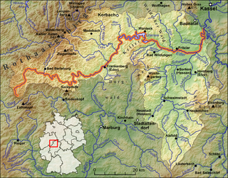
The river rises from the Ederkopf mountain in the Rothaar mountain range in eastern North Rhine-Westphalia, near the springs of the Lahn and Sieg rivers. However, unlike the Lahn and Sieg, which are both tributaries of the Rhine, the Eder flows east and north, into the river Fulda at Edermünde, south of Kassel. The Fulda then confluences with the Werra River at Hann. Münden to form the Weser River, which flows in to the North Sea.

Course of the River Eder

River profile of the Eder
Edersee Dam

Edersee Dam near Waldeck
The Edersee Dam is situated below the town of Waldeck. It is constructed of rock and concrete, and is 47 metres (154 ft) high and 400 metres (1,300 ft) long. It was completed in 1914; in 2014 its 100th birthday was celebrated.[13] It forms the Edersee lake, which is 27 kilometres (17 mi) long and contains 200 million cubic metres of water. This is used to generate hydroelectricity and to regulate water levels for shipping on the Weser river.
At low water in late summer, and during dry years, the remnants of three villages (Asel, Bringhausen, and Berich) and a bridge across the original river bed, which was submerged when the lake was filled in 1914, can be seen. Descendants of those buried there go to visit the graves of their ancestors.
Destruction of the Eder dam

Animation of the principle of the bouncing bomb. The bomb is dropped close to the surface of the lake. Because it is moving almost horizontally, at high velocity and with backspin, it bounces several times instead of sinking. Each bounce is smaller than the previous one. The "bomb run" is calculated so that at its final bounce, the bomb will reach close to the target, where it sinks. A depth charge causes it to explode at the right depth, creating destructive shockwaves. (copied content from Bouncing bomb; see that page's history for attribution)
On the night of the 17 May 1943, Avro Lancaster bombers of the RAF 617 Squadron used specially-developed bouncing bombs (codename: Upkeep) that were engineered by Barnes Wallis. They were used to destroy the Möhne, Sorpe and Eder dams, as part of Operation Chastise.[14] The dam was repaired and in use again before the end of the year. The story of the raid was documented by the 1955 film called The Dam Busters.
Tributaries of the Eder
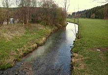
The Eder at Goddelsbach (Erndtebrück)

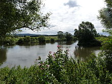
The Eder near to Frankenberg
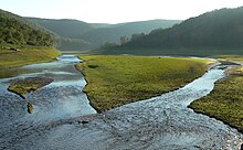
The Eder in the Edersee at low water near Asel
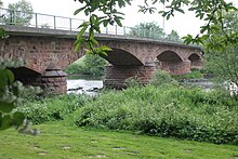
The sandstone bridge over the Eder between Altenbrunslar und Neuenbrunslar
The Eder (right) confluences near Grifte in to the Fulda (from back right to left)
The most important tributaries of the Eder are (listed first in Eder-kilometres from source to the Fulda):
| Name | orographic order | length (km) | Drainage basin (km²) | discharge (discharge rate; l/s) | mouth (Eder-kilometres) | mouth elevation (m ü. NHN) | German river numbering system |
|---|---|---|---|---|---|---|---|
| Wähbach | right | 6.0 | 6.717 | 6.9 | 514 | 428-112 | |
Benfe | right | 11.2 | 19.446 | 11.9 | 479 | 428-114 | |
| Elberndorfer Bach | left | 9.0 | 10.733 | 13.6 | 470 | 428-118 | |
| Röspe | left | 8.6 | 37.013 | 17.7 | 450 | 428-12 | |
| Kappel | left | 7.3 | 27.443 | 21.8 | 431 | 428-132 | |
| Preisdorf | right | 6.0 | 8.506 | 14.2 | 425 | 428-1334 | |
Trüfte | left | 9.7 | 16.576 | 27.1 | 413 | 428-134 | |
| Altmühlbach | right | 5.3 | 14.459 | 27.9 | 410 | 428-136 | |
| Rinther Bach | right | 6.1 | 9.12 | 30.3 | 406 | 428-138 | |
Odeborn | left | 21.2 | 85.064 | 31.3 | 403 | 428-14 | |
| Grundbach | rechts | 5.1 | 7.507 | 33.1 | 399 | 428-152 | |
| Lützelsbach | left | 5.6 | 6.437 | 34.8 | 395 | 428-154 | |
| Leisebach | right | 4.6 | 12.375 | 38.7 | 380 | 428-156 | |
| Arfe | left | 5.4 | 5.401 | 39.6 | 377 | 428-158 | |
| Lindenhöferbach | right | 4.1 | 12.034 | 189.8 | 48.9 | 349 | 428-1596 |
Elsoff | left | 19.0 | 48.925 | 948.1 | 50.0 | 345 | 428-16 |
| Eifaer Bach | right | 4.5 | 7.211 | 103.3 | 54.2 | 342 | 428-172 |
| Riedgraben | left | 7.6 | 11.319 | 173.4 | 69.0 | 305 | 428-174 |
| Elbrighäuser Bach | left | 10.8 | 17.768 | 321.3 | 70.5 | 301 | 428-176 |
| Nitzelbach | left | 10.6 | 8.397 | 132.4 | 73.7 | 295 | 428-178 |
Linspherbach | left | 18.3 | 33.107 | 565.8 | 77.0 | 286 | 428-18 |
| Hainerbach | left | 7.3 | 10.132 | 103.7 | 80.4 | 280 | 428-192 |
Goldbach | left | 9.5 | 13.838 | 155.8 | 84.5 | 273 | 428-1952 |
Nemphe | right | 14.2 | 38.383 | 293.5 | 86.9 | 270 | 428-198 |
Nuhne | left | 36.9 | 156.747 | 2661.6 | 89.3 | 267 | 428-2 |
| Lengelbach | right | 11.4 | 25.848 | 209.9 | 96.3 | 255 | 428-32 |
Orke | left | 38.2 | 278.867 | 3844.5 | 97.5 | 254 | 428-4 |
| Lorfe | right | 11.8 | 24.281 | 245.7 | 101.4 | 250 | 428-512 |
Itter* | left | 11.6 | 76.131 | 771.3 | 105.8 | 247 | 428-531 |
Aselbach* | left | 6.6 | 18.103 | 135.4 | 112.4 | 246 | 428-533 |
| Banferbach* | right | 7.2 | 16.383 | 213.9 | 115.2 | 245 | 428-535 |
Werbe* | left | 13.2 | 42.263 | 322.6 | 122.2 | 245 | 428-537 |
Reiherbach* | left | 7.4 | 27.322 | 188.9 | 122.3 | 245 | 428-538 |
Netze | left | 12.9 | 29.04 | 169.5 | 134.0 | 194 | 428-554 |
Wesebach | right | 25.3 | 63.433 | 618.2 | 135.7 | 191 | 428-56 |
Wilde | right | 17.1 | 51.868 | 471.4 | 140.6 | 183 | 428-58 |
Elbe | left | 33.7 | 123.47 | 731.3 | 146.2 | 174 | 428-6 |
Schwalm | right | 97.1 | 1298.783 | 9044.5 | 159.5 | 158 | 428-8 |
Ems | left | 34.1 | 146.214 | 753.3 | 164.9 | 151 | 428-92 |
Pilgerbach | left | 8.8 | 25.593 | 102.2 | 175.5 | 145 | 428-98 |
- rivers that used to flow to the Eder, but now flow in to the Edersee lake.
References
^ ab Hydrographic Directory of the NRW State Office for Nature, the Environment and Consumer Protection (Gewässerverzeichnis des Landesamtes für Natur, Umwelt und Verbraucherschutz NRW 2010) (xls; 4.67 MB)
^ Tacitus, The Annals 1.56
^
Guth, Werner (2008). "Mattium – Onomastische Überlegungen zu einem historischen Problem" (PDF). Zeitschrift des Vereins für hessische Geschichte. 113: 1–16. Retrieved February 19, 2015..mw-parser-output cite.citation{font-style:inherit}.mw-parser-output .citation q{quotes:"""""""'""'"}.mw-parser-output .citation .cs1-lock-free a{background:url("//upload.wikimedia.org/wikipedia/commons/thumb/6/65/Lock-green.svg/9px-Lock-green.svg.png")no-repeat;background-position:right .1em center}.mw-parser-output .citation .cs1-lock-limited a,.mw-parser-output .citation .cs1-lock-registration a{background:url("//upload.wikimedia.org/wikipedia/commons/thumb/d/d6/Lock-gray-alt-2.svg/9px-Lock-gray-alt-2.svg.png")no-repeat;background-position:right .1em center}.mw-parser-output .citation .cs1-lock-subscription a{background:url("//upload.wikimedia.org/wikipedia/commons/thumb/a/aa/Lock-red-alt-2.svg/9px-Lock-red-alt-2.svg.png")no-repeat;background-position:right .1em center}.mw-parser-output .cs1-subscription,.mw-parser-output .cs1-registration{color:#555}.mw-parser-output .cs1-subscription span,.mw-parser-output .cs1-registration span{border-bottom:1px dotted;cursor:help}.mw-parser-output .cs1-ws-icon a{background:url("//upload.wikimedia.org/wikipedia/commons/thumb/4/4c/Wikisource-logo.svg/12px-Wikisource-logo.svg.png")no-repeat;background-position:right .1em center}.mw-parser-output code.cs1-code{color:inherit;background:inherit;border:inherit;padding:inherit}.mw-parser-output .cs1-hidden-error{display:none;font-size:100%}.mw-parser-output .cs1-visible-error{font-size:100%}.mw-parser-output .cs1-maint{display:none;color:#33aa33;margin-left:0.3em}.mw-parser-output .cs1-subscription,.mw-parser-output .cs1-registration,.mw-parser-output .cs1-format{font-size:95%}.mw-parser-output .cs1-kern-left,.mw-parser-output .cs1-kern-wl-left{padding-left:0.2em}.mw-parser-output .cs1-kern-right,.mw-parser-output .cs1-kern-wl-right{padding-right:0.2em}
^
Sperber, Rüdiger (1996). "Die Nebenflüsse von Werra und Fulda bis zum Zusammenfluß". Hydronymia Germaniae. Steiner, Wiesbaden. Reihe A, Lief. 5. ISBN 978-3515006453.
^
Meier, Marcus (2008). The Origin of the Schwarzenau Brethren. Philadelphia: Brethren Encyclopedia, Inc. p. 144.
^
Kulick, J. (1998). Goldbergbau am Eisenberg bei Goldhausen. Führungsblatt zu einem Industriedenkmal des Mittelalters und der frühen Neuzeit bei Korbach-Goldhausen, Kreis Waldeck-Frankenberg [Gold mining on the Eisenberg near Goldhausen. Information]. Archäologische Denkmäler in Hessen (in German). 143. Wiesbaden: Landesamt für Denkmalpflege Hessen. ISBN 3-89822-143-1.
^
Zerrenner, Carl Michael (1851). Anleitung zum Gold-, Platin- und Diamanten-Waschen aus Seifengebirge, Ufer- und Flussbett-Sand: unter Voraussendung einer geognostischen Charakteristik des die genannten Mineralien führenden Seifengebirges und einer Zusammenstellung verschiedener Ausbeutungsmethoden desselben in verschiedenen Gegenden der Erde (in German). Leipzig.
^
Pierer's Universal-Lexikon, Band 1 [Pierer's universal encyclopedia, volume 1] (in German). Altenburg. 1857. p. 155.
^
Berghaus, Heinrich Karl Wilhelm (1838). Allgemeine Länder- und Völkerkunde: Nebst einem Abriß der physikalischen Erdbeschreibung, Band 3 [General studies of countries and people: including a shortened version of the physical Earth description, volume 3] (in German). Stuttgart: Hoffmann'sche Buckhandlung. p. 34.
^
"Obermöllrich, Schwalm-Eder-Kreis" [Obermöllrich, Schwalm-Eder District] (in German). Hessisches Landesamt für geschichtliche Landeskunde. Retrieved 13 Feb 2015.
^
Manfred Common. "Eder – Golddukat" [Eder – gold ducats] (in German). Retrieved 13 Feb 2015.
^
Veit-Enno Hoffmann. "Goldwelten - Goldsucher" [World of Gold - Gold prospecter] (in German). Archived from the original on 2015-02-13. Retrieved 13 Feb 2015.
^
Edersee Touristic GmbH. "100 Jahre Edersee" [100 years of the Edersee] (in German). Retrieved 13 Feb 2015.
^
Dildy, Douglas C. (2010). Dambusters; Operation Chastise. Osprey Raid Series No. 16. Oxford, UK: Osprey Publishing. p. 405. ISBN 978-1-84603-934-8.
| Wikimedia Commons has media related to Eder. |


