Makassar Strait
| Makassar Strait | |
|---|---|
 Makassar Strait Map | |
 Makassar Strait Location of Makassar Strait | |
| Location | Indonesia |
| Coordinates | 0°0′0″N 118°30′00″E / 0.00000°N 118.50000°E / 0.00000; 118.50000Coordinates: 0°0′0″N 118°30′00″E / 0.00000°N 118.50000°E / 0.00000; 118.50000 |
| Type | strait |
| Native name | Indonesian: Selat Makassar |
Basin countries | |
| Islands | +100 |
| Settlements | Balikpapan, Bontang (Kalimantan) Makassar, Palu, Parepare (Sulawesi) |
| References | Macassar Strait: OS (Oceans) National Geospatial-Intelligence Agency, Bethesda, MD, USA |
Makassar Strait is a strait between the islands of Borneo and Sulawesi in Indonesia. To the north it joins the Celebes Sea, while to the south it meets the Java Sea.
The Mahakam River of Borneo empties into the strait.
Ports along the strait include Balikpapan and Bontang in Borneo, and Makassar, Palu, and Parepare in Sulawesi. The city of Samarinda is 48 km (30 mi) from the strait, along the Mahakam.
Contents
1 Extent
2 Gallery
3 See also
4 References
Extent
The International Hydrographic Organization (IHO) defines the Makassar Strait as being one of the waters of the East Indian Archipelago. The IHO defines its limits as follows:[1]
The channel between the East coast of Borneo and the West coast of Celebes [Sulawesi], is bounded:
On the North. By a line joining Tanjong Mangkalihat, Borneo (1°02′N 118°57′E / 1.033°N 118.950°E / 1.033; 118.950) and Stroomen Kaap (Cape Rivers), Celebes (1°20′N 120°52′E / 1.333°N 120.867°E / 1.333; 120.867).
On the South. By a line from the Southwestern extreme of Celebes (5°37′S 119°27′E / 5.617°S 119.450°E / -5.617; 119.450), through the Southern point of Tana Keke, to the Southern extreme of Laoet (4°06′S 116°06′E / 4.100°S 116.100°E / -4.100; 116.100) thence up the West coast of that island to Tanjong Kiwi and thence across to Tanjong Petang, Borneo (3°37′S 115°57′E / 3.617°S 115.950°E / -3.617; 115.950) at the Southern end of Laoet Strait.
Gallery

Beras Basah Island in Makassar Strait, administrative part of Bontang.
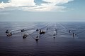
USS Midway (CV-41) and other battleships in Makassar Strait, 28 September 1985.

Offshore oil rig in Makassar Strait, 2005.

Aur island, administrative part of South Kalimantan.

KM Arista ship sunk in Makassar Strait, 10 June 2015.[2]


See also
- Battle of Makassar Strait
- USS Makassar Strait
- Strait of Malacca
- Sunda Strait
- Lombok Strait
- Wallace Line
- Sadang River
References
^ "Limits of Oceans and Seas, 3rd edition" (PDF). International Hydrographic Organization. 1953. Retrieved 7 February 2010..mw-parser-output cite.citation{font-style:inherit}.mw-parser-output .citation q{quotes:"""""""'""'"}.mw-parser-output .citation .cs1-lock-free a{background:url("//upload.wikimedia.org/wikipedia/commons/thumb/6/65/Lock-green.svg/9px-Lock-green.svg.png")no-repeat;background-position:right .1em center}.mw-parser-output .citation .cs1-lock-limited a,.mw-parser-output .citation .cs1-lock-registration a{background:url("//upload.wikimedia.org/wikipedia/commons/thumb/d/d6/Lock-gray-alt-2.svg/9px-Lock-gray-alt-2.svg.png")no-repeat;background-position:right .1em center}.mw-parser-output .citation .cs1-lock-subscription a{background:url("//upload.wikimedia.org/wikipedia/commons/thumb/a/aa/Lock-red-alt-2.svg/9px-Lock-red-alt-2.svg.png")no-repeat;background-position:right .1em center}.mw-parser-output .cs1-subscription,.mw-parser-output .cs1-registration{color:#555}.mw-parser-output .cs1-subscription span,.mw-parser-output .cs1-registration span{border-bottom:1px dotted;cursor:help}.mw-parser-output .cs1-ws-icon a{background:url("//upload.wikimedia.org/wikipedia/commons/thumb/4/4c/Wikisource-logo.svg/12px-Wikisource-logo.svg.png")no-repeat;background-position:right .1em center}.mw-parser-output code.cs1-code{color:inherit;background:inherit;border:inherit;padding:inherit}.mw-parser-output .cs1-hidden-error{display:none;font-size:100%}.mw-parser-output .cs1-visible-error{font-size:100%}.mw-parser-output .cs1-maint{display:none;color:#33aa33;margin-left:0.3em}.mw-parser-output .cs1-subscription,.mw-parser-output .cs1-registration,.mw-parser-output .cs1-format{font-size:95%}.mw-parser-output .cs1-kern-left,.mw-parser-output .cs1-kern-wl-left{padding-left:0.2em}.mw-parser-output .cs1-kern-right,.mw-parser-output .cs1-kern-wl-right{padding-right:0.2em}
^ "Navy vessel rescues 65 people in Makassar Strait | IHS Fairplay". fairplay.ihs.com. Retrieved 2018-11-30.
Earth's oceans and seas | |
|---|---|
| Arctic Ocean |
|
| Atlantic Ocean |
|
| Indian Ocean |
|
| Pacific Ocean |
|
| Southern Ocean |
|
| Endorheic basins |
|
| |
This Indonesia location article is a stub. You can help Wikipedia by expanding it. |


