Galesville, Wisconsin
Galesville, Wisconsin | |
|---|---|
City | |
 Downtown Historic District in 2017 | |
 Location of Galesville in Trempealeau County, Wisconsin. | |
| Coordinates: 44°5′1″N 91°21′13″W / 44.08361°N 91.35361°W / 44.08361; -91.35361Coordinates: 44°5′1″N 91°21′13″W / 44.08361°N 91.35361°W / 44.08361; -91.35361 | |
| Country | United States |
| State | Wisconsin |
| County | Trempealeau |
| Area [1] | |
| • Total | 1.47 sq mi (3.81 km2) |
| • Land | 1.36 sq mi (3.52 km2) |
| • Water | 0.11 sq mi (0.28 km2) |
| Elevation [2] | 728 ft (222 m) |
| Population (2010)[3] | |
| • Total | 1,481 |
| • Estimate (2016)[4] | 1,537 |
| • Density | 1,089.0/sq mi (420.5/km2) |
| Time zone | UTC-6 (Central (CST)) |
| • Summer (DST) | UTC-5 (CDT) |
| Zip Code | 54630 |
| Area code(s) | 608 |
| FIPS code | 55-28200[5] |
GNIS feature ID | 1565380[2] |
| Website | cityofgalesville.com |
Galesville is a city in Trempealeau County, Wisconsin, United States. The population was 1,481 at the 2010 census. It is located where Beaver Creek flows into a wide area of the Mississippi River valley. The creek is impounded to form Lake Marinuka. The mayor is Vince Howe.[6]
Contents
1 History
2 Geography
3 Demographics
3.1 2010 census
3.2 2000 census
4 Notable people
5 Images
6 References
7 External links
History
Galesville is named for its founder, Judge George Gale a native of Vermont.[7] It was platted by Gale in 1854.[8]
Geography
According to the United States Census Bureau, the city has a total area of 1.47 square miles (3.81 km2), of which, 1.36 square miles (3.52 km2) is land and 0.11 square miles (0.28 km2) is water.[1]
Demographics
| Historical population | |||
|---|---|---|---|
| Census | Pop. | %± | |
| 1870 | 1,068 | — | |
| 1880 | 410 | −61.6% | |
| 1890 | 537 | 31.0% | |
| 1900 | 862 | 60.5% | |
| 1910 | 973 | 12.9% | |
| 1920 | 952 | −2.2% | |
| 1930 | 1,069 | 12.3% | |
| 1940 | 1,147 | 7.3% | |
| 1950 | 1,193 | 4.0% | |
| 1960 | 1,199 | 0.5% | |
| 1970 | 1,162 | −3.1% | |
| 1980 | 1,239 | 6.6% | |
| 1990 | 1,278 | 3.1% | |
| 2000 | 1,427 | 11.7% | |
| 2010 | 1,481 | 3.8% | |
| Est. 2016 | 1,537 | [4] | 3.8% |
| U.S. Decennial Census[9] | |||
2010 census
As of the census[3] of 2010, there were 1,481 people, 635 households, and 388 families residing in the city. The population density was 1,089.0 inhabitants per square mile (420.5/km2). There were 694 housing units at an average density of 510.3 per square mile (197.0/km2). The racial makeup of the city was 96.6% White, 0.1% African American, 0.2% Native American, 1.0% Asian, 0.4% from other races, and 1.6% from two or more races. Hispanic or Latino of any race were 1.2% of the population.
There were 635 households of which 30.1% had children under the age of 18 living with them, 46.3% were married couples living together, 9.6% had a female householder with no husband present, 5.2% had a male householder with no wife present, and 38.9% were non-families. 33.7% of all households were made up of individuals and 16.1% had someone living alone who was 65 years of age or older. The average household size was 2.25 and the average family size was 2.87.
The median age in the city was 41.6 years. 22.7% of residents were under the age of 18; 6.7% were between the ages of 18 and 24; 24.7% were from 25 to 44; 27.9% were from 45 to 64; and 18.1% were 65 years of age or older. The gender makeup of the city was 47.9% male and 52.1% female.
2000 census
As of the census[5] of 2000, there were 1,427 people, 606 households, and 355 families residing in the city. The population density was 1,316.8 people per square mile (510.2/km²). There were 648 housing units at an average density of 597.9 per square mile (231.7/km²). The racial makeup of the city was 99.09% White, 0.14% African American, 0.07% Native American, 0.14% Asian, 0.07% Pacific Islander, 0.07% from other races, and 0.42% from two or more races. Hispanic or Latino of any race were 0.42% of the population.
There were 606 households out of which 29.2% had children under the age of 18 living with them, 45.7% were married couples living together, 10.4% had a female householder with no husband present, and 41.3% were non-families. 36.1% of all households were made up of individuals and 18.2% had someone living alone who was 65 years of age or older. The average household size was 2.26 and the average family size was 2.97.
In the city, the population was spread out with 24.5% under the age of 18, 8.2% from 18 to 24, 25.5% from 25 to 44, 22.3% from 45 to 64, and 19.5% who were 65 years of age or older. The median age was 40 years. For every 100 females, there were 87.3 males. For every 100 females age 18 and over, there were 81.0 males.
The median income for a household in the city was $35,054, and the median income for a family was $45,333. Males had a median income of $29,453 versus $22,137 for females. The per capita income for the city was $18,245. About 6.0% of families and 9.6% of the population were below the poverty line, including 11.9% of those under age 18 and 14.3% of those age 65 or over.
Notable people
Alexander Ahab Arnold, Speaker of the Wisconsin State Assembly
Sam Brenegan, baseball player
Eugene Clark, Wisconsin State Senator
George Gale, jurist, legislator, and founder of Galesville and Trempealeau County[10]
Charles N. Herreid, Governor of South Dakota
Suzanne Jeskewitz, Wisconsin State Assemblywoman
Frank A. Kellman, Wisconsin State Assemblyman
Norris J. Kellman, Wisconsin State Assemblyman
Elmer Petersen, sculptor of public art around La Crosse and creator of the World's Largest Buffalo
Nicholas Ray, American film director (born Raymond Nicholas Kienzle)
Albert Twesme, Wisconsin State Assemblyman and jurist
Guilford M. Wiley, Wisconsin State Assemblyman
Images
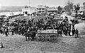
Galesville Square, 1870s

City hall / Post office / Police station
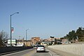
Looking north at downtown Galesville

Gale / Ettrick / Trempealeau High School
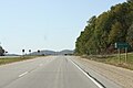
Sign

Old Main Hall at Gale College
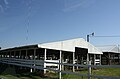
Trempealeau County fairgrounds


References
^ ab "US Gazetteer files 2010". United States Census Bureau. Archived from the original on 2012-07-14. Retrieved 2012-11-18..mw-parser-output cite.citation{font-style:inherit}.mw-parser-output q{quotes:"""""""'""'"}.mw-parser-output code.cs1-code{color:inherit;background:inherit;border:inherit;padding:inherit}.mw-parser-output .cs1-lock-free a{background:url("//upload.wikimedia.org/wikipedia/commons/thumb/6/65/Lock-green.svg/9px-Lock-green.svg.png")no-repeat;background-position:right .1em center}.mw-parser-output .cs1-lock-limited a,.mw-parser-output .cs1-lock-registration a{background:url("//upload.wikimedia.org/wikipedia/commons/thumb/d/d6/Lock-gray-alt-2.svg/9px-Lock-gray-alt-2.svg.png")no-repeat;background-position:right .1em center}.mw-parser-output .cs1-lock-subscription a{background:url("//upload.wikimedia.org/wikipedia/commons/thumb/a/aa/Lock-red-alt-2.svg/9px-Lock-red-alt-2.svg.png")no-repeat;background-position:right .1em center}.mw-parser-output .cs1-subscription,.mw-parser-output .cs1-registration{color:#555}.mw-parser-output .cs1-subscription span,.mw-parser-output .cs1-registration span{border-bottom:1px dotted;cursor:help}.mw-parser-output .cs1-hidden-error{display:none;font-size:100%}.mw-parser-output .cs1-visible-error{font-size:100%}.mw-parser-output .cs1-subscription,.mw-parser-output .cs1-registration,.mw-parser-output .cs1-format{font-size:95%}.mw-parser-output .cs1-kern-left,.mw-parser-output .cs1-kern-wl-left{padding-left:0.2em}.mw-parser-output .cs1-kern-right,.mw-parser-output .cs1-kern-wl-right{padding-right:0.2em}
^ ab "US Board on Geographic Names". United States Geological Survey. 2007-10-25. Retrieved 2008-01-31.
^ ab "American FactFinder". United States Census Bureau. Retrieved 2012-11-18.
^ ab "Population and Housing Unit Estimates". Retrieved June 9, 2017.
^ ab "American FactFinder". United States Census Bureau. Archived from the original on 2013-09-11. Retrieved 2008-01-31.
^ City of Galesville
^ Gannett, Henry (1905). The Origin of Certain Place Names in the United States. Govt. Print. Off. p. 133.
^ Galesville City website
^ "Census of Population and Housing". Census.gov. Archived from the original on May 12, 2015. Retrieved June 4, 2015.
^ http://www.tremplocounty.com/circuitcourt/george_galecounty_judge.htm
External links
| Wikimedia Commons has media related to Galesville, Wisconsin. |
- City of Galesville
- Galesville Chamber of Commerce
- Sanborn fire insurance maps: 1894 1900 1910
Municipalities and communities of Trempealeau County, Wisconsin, United States | ||
|---|---|---|
County seat: Whitehall | ||
| Cities |
|  |
| Villages |
| |
| Towns |
| |
| CDP |
| |
| Unincorporated communities |
| |
Ghost towns/neighborhoods |
| |


