Batholith

Half Dome, a granite monolith in Yosemite National Park and part of the Sierra Nevada Batholith
This article includes a list of references, but its sources remain unclear because it has insufficient inline citations. (March 2015) (Learn how and when to remove this template message) |
A batholith (from Greek bathos, depth + lithos, rock) is a large mass of intrusive igneous rock (also called plutonic rock), larger than 100 square kilometres (40 sq mi) in area,[1] that forms from cooled magma deep in the Earth's crust. Batholiths are almost always made mostly of felsic or intermediate rock types, such as granite, quartz monzonite, or diorite (see also granite dome).
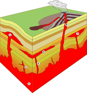
Basic types of intrusions: 1. Laccolith
2. Small dike
3. Batholith
4. Dike
5. Sill
6. Volcanic neck, pipe
7. Lopolith
Note: As a general rule, in contrast to the smoldering volcanic vent in the figure, these names refer to the fully cooled and usually millions-of-years-old rock formations, which are the result of the underground magmatic activity shown.
Contents
1 Formation
2 Surface expression and erosion
3 Examples
3.1 Africa
3.2 Antarctica
3.3 Asia
3.4 Europe
3.5 North America
3.6 Oceania
3.7 South America
4 See also
5 References
6 External links
Formation
Although they may appear uniform, batholiths are in fact structures with complex histories and compositions. They are composed of multiple masses, or plutons, bodies of igneous rock of irregular dimensions (typically at least several kilometers) that can be distinguished from adjacent igneous rock by some combination of criteria including age, composition, texture, or mappable structures. Individual plutons are solidified from magma that traveled toward the surface from a zone of partial melting near the base of the Earth's crust.

The eroded laccolith above the batholith system of Vitosha - Plana domed mountains, next to Sofia, Bulgaria
Traditionally, these plutons have been considered to form by ascent of relatively buoyant magma in large masses called plutonic diapirs. Because the diapirs are liquified and very hot, they tend to rise through the surrounding native country rock, pushing it aside and partially melting it. Most diapirs do not reach the surface to form volcanoes, but instead they slow down, cool, and usually solidify 5 to 30 kilometers underground as plutons (hence the use of the word pluton; in reference to the Roman god of the underworld Pluto). An alternate view is that plutons commonly are formed not by ascent of large magma diapirs, but rather by aggregation of smaller volumes of magma that ascend as dikes.[2]
A batholith is formed when many plutons converge to form a huge expanse of granitic rock. Some batholiths are mammoth, paralleling past and present subduction zones and other heat sources for hundreds of kilometers in continental crust. One such batholith is the Sierra Nevada Batholith, which is a continuous granitic formation that makes up much of the Sierra Nevada in California. An even larger batholith, the Coast Plutonic Complex, is found predominantly in the Coast Mountains of western Canada; it extends for 1,800 kilometers and reaches into southeastern Alaska.
Surface expression and erosion
A batholith is an exposed area of (mostly) continuous plutonic rock that covers an area larger than 100 square kilometers (40 square miles). Areas smaller than 100 square kilometers are called stocks.[3] However, the majority of batholiths visible at the surface (via outcroppings) have areas far greater than 100 square kilometers. These areas are exposed to the surface through the process of erosion accelerated by continental uplift acting over many tens of millions to hundreds of millions of years. This process has removed several tens of square kilometers of overlying rock in many areas, exposing the once deeply buried batholiths.
Batholiths exposed at the surface are subjected to huge pressure differences between their former location deep in the earth and their new location at or near the surface. As a result, their crystal structure expands slightly over time. This manifests itself by a form of mass wasting called exfoliation. This form of weathering causes convex and relatively thin sheets of rock to slough off the exposed surfaces of batholiths (a process accelerated by frost wedging). The result is fairly clean and rounded rock faces. A well-known result of this process is Half Dome in Yosemite Valley.
Examples
Africa
- Aswan Granite Batholith
- Cape Coast Batholith, Ghana
- Darling Batholith, South Africa
Hook granite massif, Zambia- Mubende Batholith, Uganda
Antarctica
- Antarctic Peninsula Batholith
- Queen Maud Batholith
Asia
Angara-Vitim batholith, Siberia
Bhongir Fort Batholith, Telangana, India[4]
Gangdese batholith, Himalaya- Trans-Himalayan Batholith, Himalaya
Kalba-Narym batholith, Kazakhstan- Karakorum Batholith, Himalaya
- Tak batholith, Thailand
- Tien Shan batholith, Central Asia
Europe
- Bindal Batholith, Norway
Cornubian batholith, England- Corsica-Sardinia Batholith
Donegal batholith, Ireland- Leinster Batholith, Ireland
- Mancellian batholith, France
North Pennine Batholith, England
Ljusdal Batholith, Sweden- Mt-Louis-Andorra Batholith
- Riga Batholith, Latvia
- Salmi Batholith, Republic of Karelia, Russia
- Sunnhordaland Batholith, Norway
Transscandinavian Igneous Belt, Sweden and Norway
- Revsund Massif
- Rätan Batholith
- Småland–Värmland Belt
North America
- Bald Rock Batholith
- Boulder Batholith
- British Virgin Islands
- Chambers-Strathy Batholith
Town Mountain Granite batholith, Texas- Golden Horn Batholith
- Idaho Batholith
- Ilimaussaq Batholith, Greenland
- Kenosha Batholith
- Ruby Mountains
- Rio Verde Batholith, Mexico
- Sierra Nevada Batholith
- South Mountain Batholith, Nova Scotia
Peninsular Ranges, Baja and Southern California[5]
- Stone Mountain
- Pike's Peak Granite Batholith
- Chilliwack batholith
Wyoming batholith[6]
Oceania
- Cullen Batholith, Australia
Kosciuszko Batholith, Australia
Moruya Batholith, Australia- Median Batholith, New Zealand
- New England Batholith, Australia
South America
Achala Batholith, Argentina
Antioquia Batholith, Colombia- Guanambi Batholith, Bahia, Brazil
Parguaza rapakivi granite Batholith, Venezuela and Colombia
Cerro Aspero Batholith, Argentina- Coastal Batholith of Peru
Colangüil Batholith, Argentina
Cordillera Blanca Batholith, Peru
Vicuña Mackenna Batholith, Chile
Elqui-Limarí Batholith, Chile and Argentina
Futrono-Riñihue Batholith, Chile
Illescas Batholith, Uruguay- Coastal Batholith of central Chile
Panguipulli Batholith, Chile- Patagonian Batholith, Chile and Argentina
- North Patagonian Batholith
- South Patagonian Batholith
See also
- Laccolith
- Sill
- Stock
- Volcanic plug
References
^ Petersen, James F.; Sack, Dorothy; Gabler, Robert E. (2017). Physical Geography (11th edition). Boston: Cengage Learning Inc. p. 614. ISBN 978-1-305-65264-4..mw-parser-output cite.citation{font-style:inherit}.mw-parser-output .citation q{quotes:"""""""'""'"}.mw-parser-output .citation .cs1-lock-free a{background:url("//upload.wikimedia.org/wikipedia/commons/thumb/6/65/Lock-green.svg/9px-Lock-green.svg.png")no-repeat;background-position:right .1em center}.mw-parser-output .citation .cs1-lock-limited a,.mw-parser-output .citation .cs1-lock-registration a{background:url("//upload.wikimedia.org/wikipedia/commons/thumb/d/d6/Lock-gray-alt-2.svg/9px-Lock-gray-alt-2.svg.png")no-repeat;background-position:right .1em center}.mw-parser-output .citation .cs1-lock-subscription a{background:url("//upload.wikimedia.org/wikipedia/commons/thumb/a/aa/Lock-red-alt-2.svg/9px-Lock-red-alt-2.svg.png")no-repeat;background-position:right .1em center}.mw-parser-output .cs1-subscription,.mw-parser-output .cs1-registration{color:#555}.mw-parser-output .cs1-subscription span,.mw-parser-output .cs1-registration span{border-bottom:1px dotted;cursor:help}.mw-parser-output .cs1-ws-icon a{background:url("//upload.wikimedia.org/wikipedia/commons/thumb/4/4c/Wikisource-logo.svg/12px-Wikisource-logo.svg.png")no-repeat;background-position:right .1em center}.mw-parser-output code.cs1-code{color:inherit;background:inherit;border:inherit;padding:inherit}.mw-parser-output .cs1-hidden-error{display:none;font-size:100%}.mw-parser-output .cs1-visible-error{font-size:100%}.mw-parser-output .cs1-maint{display:none;color:#33aa33;margin-left:0.3em}.mw-parser-output .cs1-subscription,.mw-parser-output .cs1-registration,.mw-parser-output .cs1-format{font-size:95%}.mw-parser-output .cs1-kern-left,.mw-parser-output .cs1-kern-wl-left{padding-left:0.2em}.mw-parser-output .cs1-kern-right,.mw-parser-output .cs1-kern-wl-right{padding-right:0.2em}
^ Hall, Clarence A., Jr. (2007). Introduction to the geology of southern California and its native plants. Berkeley: University of California Press. p. 22. ISBN 9780520249325.
^ GLENCOE SCIENCE | Earth Science Twelfth Grade High School Textbook (Georgia); pg. 115 paragraph 1, pg. 521 question 9
^ http://www.deccanchronicle.com/nation/in-other-news/010616/telangana-bhongir-fort-s-batholith-marvel.html
^ Douglas M. Morton, Fred K. Miller, Peninsular Ranges Batholith, Baja and Southern California, Geological Society of America, 2014
^ Davin A. Bagdonas; Carol D. Frost; C. Mark Fanning (2016). "The origin of extensive Neoarchean high-silica batholiths and the nature of intrusive complements to silicic ignimbrites: Insights from the Wyoming batholith, U.S.A." (PDF). American Mineralogist. 101: 1332–1347. Retrieved June 8, 2016....Neoarchean granite batholith, herein named the Wyoming batholith, extends more than 200 km across central Wyoming in the Granite and the Laramie Mountains.
- Plummer, McGeary, Carlson, Physical Geology, Eighth Edition (McGraw-Hill: Boston, 1999) pages 61–63
ISBN 0-697-37404-1
- Glazner, Bartley, Coleman, Gray, Taylor, Are plutons assembled over millions of years by amalgamation from small magma chambers?, GSA Today: Vol. 14, No. 4, pp. 4–11
External links
- Idaho Batholith
- The Cornubian Batholith


