Cerro Macá
| Cerro Macá | |
|---|---|
 | |
| Highest point | |
| Elevation | 2,300 m (7,500 ft) [1][2] |
| Prominence | 2,066 m (6,778 ft) [2] |
| Listing | Ultra |
| Coordinates | 45°06′21″S 73°10′09″W / 45.10583°S 73.16917°W / -45.10583; -73.16917Coordinates: 45°06′21″S 73°10′09″W / 45.10583°S 73.16917°W / -45.10583; -73.16917 [2] |
| Geography | |
 Cerro Macá Location of Cerro Maca | |
| Location | Chile |
| Parent range | Andes |
| Geology | |
| Mountain type | Stratovolcano |
| Last eruption | 410 CE ± 50 years |
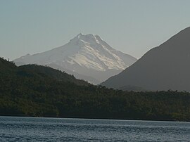
Cerro Macá is a stratovolcano located to the north of the Aisén Fjord and to the east of the Moraleda Channel, in the Aysén del General Carlos Ibáñez del Campo Region of Chile. This glacier-covered volcano lies along the regional Liquiñe-Ofqui Fault Zone.[3]
Cerro Macá is a relatively small volcano with a volume of only 39 cubic kilometres (9.4 cu mi).[4]It has a summit elevation of approximately 2,300 m above sea level[1][2] and features glaciers[5] that in 2011 covered an area of 27.62 square kilometres (10.66 sq mi).[6] The edifice is partially eroded[7] and a sector collapse is probably the origin of a large steep sided depression in the summit area.[8]Pyroclastic cones with associated lava flows are found on its southwestern flank[9] but also on the other slopes of the volcano, as far down as sea level and in the Bahia Aysen.[10]
The volcano is part of the southernmost Southern Volcanic Zone of Chile, where volcanism is caused by the subduction of the Nazca Plate. Other volcanoes in the area are Melimoyu, Mentolat, Cay and Cerro Hudson.[11] Macá specifically is formed by basalt and basaltic andesite.[12]
1,440 ± 40 calibrated radiocarbon years ago a moderate explosive eruption deposited the MAC1 tephra,[13] which reaches thicknesses of 10–15 centimetres (3.9–5.9 in) 70 kilometres (43 mi) east of Macá.[14] Ash from past eruptions has been tentatively identified close to Cochrane Lake.[15] A more recent eruption occurred in 410 ± 50 AD.[16]
In the early 20th century volcanic activity was observed at Ensenada Pérez, close to the southwestern flank of Macá.[17]
See also
- List of volcanoes in Chile
- List of Ultras of South America
Footnotes
^ ab The elevation given here is from SRTM data and independently confirmed by ASTER GDEM. Elevations around 3,000 m given by other authorities should be discounted. The contours around the summit are missing from official Chilean topographic mapping.
^ abcd "Argentina and Chile, Southern: Patagonia Ultra-Prominences" Peaklist.org. Listed as "Volcán Maca". Maca is a smooth volcanic cone, and SRTM indicates a summit elevation of 2300m ± 20m. This is supported by Biggar in "The Andes". Cited elevations of 2960-3079m are based on gross exaggeration.Note 9 Retrieved 2012-04-16.
^ Finnische Expedition nach Patagonien; Väinö Auer (1941). Wissenschaftliche Ergebnisse der Finnischen Expedition nach Patagonien 1937-38 (in German). p. 79..mw-parser-output cite.citation{font-style:inherit}.mw-parser-output .citation q{quotes:"""""""'""'"}.mw-parser-output .citation .cs1-lock-free a{background:url("//upload.wikimedia.org/wikipedia/commons/thumb/6/65/Lock-green.svg/9px-Lock-green.svg.png")no-repeat;background-position:right .1em center}.mw-parser-output .citation .cs1-lock-limited a,.mw-parser-output .citation .cs1-lock-registration a{background:url("//upload.wikimedia.org/wikipedia/commons/thumb/d/d6/Lock-gray-alt-2.svg/9px-Lock-gray-alt-2.svg.png")no-repeat;background-position:right .1em center}.mw-parser-output .citation .cs1-lock-subscription a{background:url("//upload.wikimedia.org/wikipedia/commons/thumb/a/aa/Lock-red-alt-2.svg/9px-Lock-red-alt-2.svg.png")no-repeat;background-position:right .1em center}.mw-parser-output .cs1-subscription,.mw-parser-output .cs1-registration{color:#555}.mw-parser-output .cs1-subscription span,.mw-parser-output .cs1-registration span{border-bottom:1px dotted;cursor:help}.mw-parser-output .cs1-ws-icon a{background:url("//upload.wikimedia.org/wikipedia/commons/thumb/4/4c/Wikisource-logo.svg/12px-Wikisource-logo.svg.png")no-repeat;background-position:right .1em center}.mw-parser-output code.cs1-code{color:inherit;background:inherit;border:inherit;padding:inherit}.mw-parser-output .cs1-hidden-error{display:none;font-size:100%}.mw-parser-output .cs1-visible-error{font-size:100%}.mw-parser-output .cs1-maint{display:none;color:#33aa33;margin-left:0.3em}.mw-parser-output .cs1-subscription,.mw-parser-output .cs1-registration,.mw-parser-output .cs1-format{font-size:95%}.mw-parser-output .cs1-kern-left,.mw-parser-output .cs1-kern-wl-left{padding-left:0.2em}.mw-parser-output .cs1-kern-right,.mw-parser-output .cs1-kern-wl-right{padding-right:0.2em}
^ Weller, Derek J.; Porras, De; Eugenia, María; Maldonado, Antonio; Méndez, César; Stern, Charles R.; Weller, Derek J.; Porras, De; Eugenia, María; Maldonado, Antonio; Méndez, César; Stern, Charles R. (2017). "Tefrocronología holocena del curso inferior del valle de río Cisnes, Chile austral". Andean Geology. 44 (3): 229–248. doi:10.5027/andgeov44n3-a01. ISSN 0718-7106.
^ Masiokas, Mariano H.; Rivera, Andrés; Espizua, Lydia E.; Villalba, Ricardo; Delgado, Silvia; Aravena, Juan Carlos (October 2009). "Glacier fluctuations in extratropical South America during the past 1000years". Palaeogeography, Palaeoclimatology, Palaeoecology. 281 (3–4): 242–268. doi:10.1016/j.palaeo.2009.08.006. ISSN 0031-0182.
^ Rivera, Andrés; Bown, Francisca (August 2013). "Recent glacier variations on active ice capped volcanoes in the Southern Volcanic Zone (37°–46°S), Chilean Andes". Journal of South American Earth Sciences. 45: 345–356. doi:10.1016/j.jsames.2013.02.004. ISSN 0895-9811.
^ Naranjo, José A.; Stern, Charles R. (December 2004). "Holocene tephrochronology of the southernmost part (42°30'-45°S) of the Andean Southern Volcanic Zone". Revista Geológica de Chile. 31 (2): 224–240. doi:10.4067/S0716-02082004000200003. ISSN 0716-0208.
^ D'Orazio, M; Innocenti, F; Manetti, P; Tamponi, M; Tonarini, S; González-Ferrán, O; Lahsen, A; Omarini, R (August 2003). "The Quaternary calc-alkaline volcanism of the Patagonian Andes close to the Chile triple junction: geochemistry and petrogenesis of volcanic rocks from the Cay and Maca volcanoes (∼45°S, Chile)". Journal of South American Earth Sciences. 16 (4): 219–242. doi:10.1016/S0895-9811(03)00063-4. ISSN 0895-9811.
^ Naranjo, José Antonio; Arenas, Manuel; Clavero, Jorge; Muñoz, Oscar (2009). "Mass movement-induced tsunamis: main effects during the Patagonian Fjordland seismic crisis in Aisén (45°25'S), Chile". Andean Geology. 36 (1). ISSN 0718-7092.
^ D'Orazio, M; Innocenti, F; Manetti, P; Tamponi, M; Tonarini, S; González-Ferrán, O; Lahsen, A; Omarini, R (August 2003). "The Quaternary calc-alkaline volcanism of the Patagonian Andes close to the Chile triple junction: geochemistry and petrogenesis of volcanic rocks from the Cay and Maca volcanoes (∼45°S, Chile)". Journal of South American Earth Sciences. 16 (4): 219–242. doi:10.1016/S0895-9811(03)00063-4. ISSN 0895-9811.
^ Weller, Derek J.; Porras, De; Eugenia, María; Maldonado, Antonio; Méndez, César; Stern, Charles R.; Weller, Derek J.; Porras, De; Eugenia, María; Maldonado, Antonio; Méndez, César; Stern, Charles R. (2017). "Tefrocronología holocena del curso inferior del valle de río Cisnes, Chile austral". Andean Geology. 44 (3): 229–248. doi:10.5027/andgeov44n3-a01. ISSN 0718-7106.
^ Weller, Derek J.; Porras, De; Eugenia, María; Maldonado, Antonio; Méndez, César; Stern, Charles R.; Weller, Derek J.; Porras, De; Eugenia, María; Maldonado, Antonio; Méndez, César; Stern, Charles R. (2017). "Tefrocronología holocena del curso inferior del valle de río Cisnes, Chile austral". Andean Geology. 44 (3): 229–248. doi:10.5027/andgeov44n3-a01. ISSN 0718-7106.
^ Weller, Derek J.; Porras, De; Eugenia, María; Maldonado, Antonio; Méndez, César; Stern, Charles R.; Weller, Derek J.; Porras, De; Eugenia, María; Maldonado, Antonio; Méndez, César; Stern, Charles R. (2017). "Tefrocronología holocena del curso inferior del valle de río Cisnes, Chile austral". Andean Geology. 44 (3): 229–248. doi:10.5027/andgeov44n3-a01. ISSN 0718-7106.
^ Naranjo, José A.; Stern, Charles R. (December 2004). "Holocene tephrochronology of the southernmost part (42°30'-45°S) of the Andean Southern Volcanic Zone". Revista Geológica de Chile. 31 (2): 224–240. doi:10.4067/S0716-02082004000200003. ISSN 0716-0208.
^ Villa-Martínez, Rodrigo; Moreno, Patricio I.; Valenzuela, Marcela A. (January 2012). "Deglacial and postglacial vegetation changes on the eastern slopes of the central Patagonian Andes (47°S)". Quaternary Science Reviews. 32: 86–99. doi:10.1016/j.quascirev.2011.11.008. ISSN 0277-3791.
^ Van Daele, Maarten; Versteeg, Willem; Pino, Mario; Urrutia, Roberto; De Batist, Marc (March 2013). "Widespread deformation of basin-plain sediments in Aysén fjord (Chile) due to impact by earthquake-triggered, onshore-generated mass movements". Marine Geology. 337: 67–79. doi:10.1016/j.margeo.2013.01.006. ISSN 0025-3227.
^ Naranjo, José Antonio; Arenas, Manuel; Clavero, Jorge; Muñoz, Oscar (2009). "Mass movement-induced tsunamis: main effects during the Patagonian Fjordland seismic crisis in Aisén (45°25'S), Chile". Andean Geology. 36 (1). ISSN 0718-7092.
References
"Maca". Global Volcanism Program. Smithsonian Institution.
- "Monte Maca, Chile" on Peakbagger
This Aysén Region location article is a stub. You can help Wikipedia by expanding it. |


