Neshoba County, Mississippi
Neshoba County, Mississippi | |
|---|---|
| County | |
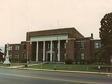 Neshoba County courthouse and Confederate Monument in Philadelphia | |
 Location within the U.S. state of Mississippi | |
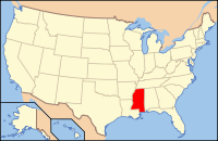 Mississippi's location within the U.S. | |
| Founded | 1833 |
| Seat | Philadelphia |
| Largest city | Philadelphia |
| Area | |
| • Total | 572 sq mi (1,481 km2) |
| • Land | 570 sq mi (1,476 km2) |
| • Water | 1.5 sq mi (4 km2), 0.3% |
| Population (est.) | |
| • (2015) | 29,463 |
| • Density | 52/sq mi (20/km2) |
| Congressional district | 3rd |
| Time zone | Central: UTC−6/−5 |
| Website | www.neshobacounty.net |
Neshoba County is a county located in the U.S. state of Mississippi. As of the 2010 census, the population was 29,676.[1] Its county seat is Philadelphia.[2] It was named after Nashoba, a Choctaw chief. His name means "wolf" in the Choctaw language.[3]
The county is known for the Neshoba County Fair and harness horse races. It is home of the Williams Brothers Store, which has been in operation since the early 1900s.
The Mississippi Band of Choctaw Indians (MBCI), a federally recognized tribe, own one of the largest casino complexes in the state. The Silver Star and Golden Moon casinos are the first land-based casinos in Mississippi. These casinos are part of the MBCI's Pearl River Resort.
Contents
1 History
2 Geography
2.1 Major highways
2.2 Adjacent counties
3 Demographics
4 Communities
4.1 Cities
4.2 Town
4.3 Census-designated places
4.4 Unincorporated communities
5 Politics
6 See also
7 Footnotes
8 Further reading
9 External links
History
Neshoba County is known as the site of one of the most infamous race-related crimes in American history, which took place in 1964 during Freedom Summer in Mississippi, a period of heightened civil rights activity in a voter registration drive. White supremacists brutally murdered three civil rights activists, Chaney, Goodman and Schwerner in Philadelphia, the county seat.
Deputy Sheriff Cecil Price was implicated but never charged with being part of the group that lynched the three young men and buried them in an earthen dam 15 miles northeast of Philadelphia. The crime and decades-long legal aftermath of investigation and trials inspired the 1988 movie Mississippi Burning.
In 1980 President Ronald Reagan launched his presidential campaign from the Neshoba County Fair, delivering a speech about economic policy and referring to "states' rights". It was believed to be referring to southern conservative values, in an area associated with the 1964 murders.[4][5]
Geography
According to the U.S. Census Bureau, the county has a total area of 572 square miles (1,480 km2), of which 570 square miles (1,500 km2) is land and 1.5 square miles (3.9 km2) (0.3%) is water.[6]
Major highways
 Mississippi Highway 15
 Mississippi Highway 16
 Mississippi Highway 19
 Mississippi Highway 21
Adjacent counties
Winston County (north)
Kemper County (east)
Newton County (south)
Leake County (west)
Demographics
| Historical population | |||
|---|---|---|---|
| Census | Pop. | %± | |
| 1840 | 2,437 | — | |
| 1850 | 4,728 | 94.0% | |
| 1860 | 8,343 | 76.5% | |
| 1870 | 7,439 | −10.8% | |
| 1880 | 8,741 | 17.5% | |
| 1890 | 11,146 | 27.5% | |
| 1900 | 12,726 | 14.2% | |
| 1910 | 17,980 | 41.3% | |
| 1920 | 19,303 | 7.4% | |
| 1930 | 26,691 | 38.3% | |
| 1940 | 27,882 | 4.5% | |
| 1950 | 25,730 | −7.7% | |
| 1960 | 20,927 | −18.7% | |
| 1970 | 20,802 | −0.6% | |
| 1980 | 23,789 | 14.4% | |
| 1990 | 24,800 | 4.2% | |
| 2000 | 28,684 | 15.7% | |
| 2010 | 29,676 | 3.5% | |
| Est. 2016 | 29,403 | [7] | −0.9% |
| U.S. Decennial Census[8] 1790-1960[9] 1900-1990[10] 1990-2000[11] 2010-2013[1] | |||
As of the census[12] of 2000, there were 28,684 people, 10,694 households, and 7,742 families residing in the county. The population density was 50 people per square mile (19/km²). There were 11,980 housing units at an average density of 21 per square mile (8/km²). The racial makeup of the county was 65.50% White, 19.33% Black or African American, 13.80% Native American, 0.19% Asian, 0.02% Pacific Islander, 0.34% from other races, and 0.81% from two or more races. 1.16% of the population were Hispanic or Latino of any race. 28.6% identified as of American ancestry, 8.8% as Irish and 6.1% as English, according to Census 2000. Those who identify as having "American" ancestry are predominantly of English descent, but have ancestors who came to the US so long ago that they identify simply as American.[13][14] 88.7% spoke English and 10.2% Choctaw as their first language.
There were 10,694 households out of which 34.90% had children under the age of 18 living with them, 52.50% were married couples living together, 15.60% had a female householder with no husband present, and 27.60% were non-families. 24.70% of all households were made up of individuals and 11.50% had someone living alone who was 65 years of age or older. The average household size was 2.63 and the average family size was 3.11.
In the county, the population was spread out with 28.20% under the age of 18, 9.00% from 18 to 24, 27.00% from 25 to 44, 21.60% from 45 to 64, and 14.20% who were 65 years of age or older. The median age was 35 years. For every 100 females there were 91.10 males. For every 100 females age 18 and over, there were 88.30 males.
The median income for a household in the county was $28,300, and the median income for a family was $33,439. Males had a median income of $28,112 versus $19,882 for females. The per capita income for the county was $14,964. About 17.90% of families and 21.00% of the population were below the poverty line, including 27.20% of those under age 18 and 22.00% of those age 65 or over.
Communities
Cities
Philadelphia (county seat)
Town
Union (mostly in Newton County)
Census-designated places
Bogue Chitto (partly in Kemper County)- Pearl River
- Tucker
Unincorporated communities
- Burnside
- Choctaw
- Good Hope
- Neshoba
- Sandtown
- Stallo
Politics
| Year | Republican | Democratic | Third parties |
|---|---|---|---|
2016 | 72.8% 7,679 | 25.7% 2,715 | 1.5% 159 |
2012 | 71.2% 7,837 | 28.0% 3,089 | 0.8% 89 |
2008 | 72.0% 8,209 | 27.3% 3,114 | 0.7% 79 |
2004 | 74.7% 7,780 | 25.0% 2,600 | 0.4% 39 |
2000 | 70.7% 6,409 | 28.3% 2,563 | 1.0% 94 |
1996 | 58.4% 4,545 | 34.0% 2,646 | 7.7% 596 |
1992 | 61.1% 6,135 | 30.8% 3,090 | 8.1% 817 |
1988 | 68.1% 6,363 | 31.5% 2,942 | 0.5% 42 |
1984 | 71.7% 6,715 | 28.1% 2,630 | 0.2% 19 |
1980 | 56.5% 5,165 | 42.3% 3,872 | 1.2% 112 |
1976 | 49.4% 3,859 | 49.8% 3,891 | 0.9% 69 |
1972 | 88.2% 6,815 | 10.5% 812 | 1.3% 98 |
1968 | 6.8% 531 | 11.1% 867 | 82.1% 6,417 |
1964 | 94.9% 5,431 | 5.1% 293 | |
1960 | 14.0% 580 | 44.5% 1,840 | 41.5% 1,716 |
1956 | 13.8% 502 | 77.9% 2,827 | 8.3% 300 |
1952 | 23.3% 1,081 | 76.7% 3,567 | |
1948 | 1.1% 33 | 8.3% 260 | 90.6% 2,837 |
1944 | 4.2% 131 | 95.9% 3,025 | |
1940 | 2.6% 77 | 97.1% 2,880 | 0.3% 10 |
1936 | 1.9% 67 | 98.0% 3,495 | 0.1% 3 |
1932 | 2.4% 56 | 97.2% 2,236 | 0.4% 8 |
1928 | 21.3% 516 | 78.7% 1,906 | |
1924 | 12.5% 228 | 87.6% 1,603 | |
1920 | 13.7% 182 | 82.1% 1,088 | 4.2% 55 |
1916 | 4.4% 69 | 92.9% 1,459 | 2.7% 43 |
1912 | 2.4% 22 | 89.0% 806 | 8.6% 78 |
See also
- National Register of Historic Places listings in Neshoba County, Mississippi
- Neshoba (film)
- Iris Kelso
Footnotes
^ ab "State & County QuickFacts". United States Census Bureau. Archived from the original on July 15, 2011. Retrieved September 4, 2013..mw-parser-output cite.citation{font-style:inherit}.mw-parser-output .citation q{quotes:"""""""'""'"}.mw-parser-output .citation .cs1-lock-free a{background:url("//upload.wikimedia.org/wikipedia/commons/thumb/6/65/Lock-green.svg/9px-Lock-green.svg.png")no-repeat;background-position:right .1em center}.mw-parser-output .citation .cs1-lock-limited a,.mw-parser-output .citation .cs1-lock-registration a{background:url("//upload.wikimedia.org/wikipedia/commons/thumb/d/d6/Lock-gray-alt-2.svg/9px-Lock-gray-alt-2.svg.png")no-repeat;background-position:right .1em center}.mw-parser-output .citation .cs1-lock-subscription a{background:url("//upload.wikimedia.org/wikipedia/commons/thumb/a/aa/Lock-red-alt-2.svg/9px-Lock-red-alt-2.svg.png")no-repeat;background-position:right .1em center}.mw-parser-output .cs1-subscription,.mw-parser-output .cs1-registration{color:#555}.mw-parser-output .cs1-subscription span,.mw-parser-output .cs1-registration span{border-bottom:1px dotted;cursor:help}.mw-parser-output .cs1-ws-icon a{background:url("//upload.wikimedia.org/wikipedia/commons/thumb/4/4c/Wikisource-logo.svg/12px-Wikisource-logo.svg.png")no-repeat;background-position:right .1em center}.mw-parser-output code.cs1-code{color:inherit;background:inherit;border:inherit;padding:inherit}.mw-parser-output .cs1-hidden-error{display:none;font-size:100%}.mw-parser-output .cs1-visible-error{font-size:100%}.mw-parser-output .cs1-maint{display:none;color:#33aa33;margin-left:0.3em}.mw-parser-output .cs1-subscription,.mw-parser-output .cs1-registration,.mw-parser-output .cs1-format{font-size:95%}.mw-parser-output .cs1-kern-left,.mw-parser-output .cs1-kern-wl-left{padding-left:0.2em}.mw-parser-output .cs1-kern-right,.mw-parser-output .cs1-kern-wl-right{padding-right:0.2em}
^ "Find a County". National Association of Counties. Retrieved 2011-06-07.
^ Byington, Cyrus (1909). Choctaw Language Dictionary. Global Bible Society.
^ Jim Prince: "War over Reagan's Words." Madison County Journal (11/22/2007)
^
Montaldo, Charles. "The Mississippi Burning Case".
^ "2010 Census Gazetteer Files". United States Census Bureau. August 22, 2012. Archived from the original on September 28, 2013. Retrieved November 6, 2014.
^ "Population and Housing Unit Estimates". Retrieved June 9, 2017.
^ "U.S. Decennial Census". United States Census Bureau. Retrieved November 6, 2014.
^ "Historical Census Browser". University of Virginia Library. Retrieved November 6, 2014.
^ "Population of Counties by Decennial Census: 1900 to 1990". United States Census Bureau. Retrieved November 6, 2014.
^ "Census 2000 PHC-T-4. Ranking Tables for Counties: 1990 and 2000" (PDF). United States Census Bureau. Retrieved November 6, 2014.
^ "American FactFinder". United States Census Bureau. Retrieved 2008-01-31.
^ Lieberson, Stanley & Waters, Mary C. (1986). "Ethnic Groups in Flux: The Changing Ethnic Responses of American Whites". Annals of the American Academy of Political and Social Science. 487 (79): 82–86. doi:10.1177/0002716286487001004.
^ Fischer, David Hackett (1989). Albion's Seed: Four British Folkways in America. New York: Oxford University Press. pp. 633–639. ISBN 0-19-503794-4.
^ Leip, David. "Dave Leip's Atlas of U.S. Presidential Elections". uselectionatlas.org. Retrieved 2018-03-04.
Further reading
- Carol V.R. George, One Mississippi, Two Mississippi: Methodists, Murder, and the Struggle for Racial Justice in Neshoba County. Oxford, England: Oxford University Press, 2015.
External links
Mississippi Region Grapples with Legacy of Civil Rights Murders, a 40th anniversary story from All Things Considered
- Neshoba Democrat's 40th anniversary stories
Places adjacent to Neshoba County, Mississippi | ||||||||||
|---|---|---|---|---|---|---|---|---|---|---|
| ||||||||||
Municipalities and communities of Neshoba County, Mississippi, United States | ||
|---|---|---|
County seat: Philadelphia | ||
| Cities |
|  |
| Town |
| |
| CDPs |
| |
| Other communities |
| |
| Indian reservation |
| |
| Footnotes | ‡This populated place also has portions in an adjacent county or counties | |
Jackson (capital) | ||
| Topics |
|  Seal of Mississippi |
| Society |
| |
| Regions |
| |
| Metros |
| |
| Larger cities |
| |
| Smaller cities |
| |
| Counties |
| |
Authority control |
|
|---|
Coordinates: 32°45′N 89°07′W / 32.75°N 89.12°W / 32.75; -89.12


