Chatham, Illinois
Chatham | |
|---|---|
Village | |
| Motto(s): Where families grow. | |
 Location of Chatham in Sangamon County, Illinois. | |
 Location of Illinois in the United States | |
| Coordinates: 39°40′22″N 89°41′54″W / 39.67278°N 89.69833°W / 39.67278; -89.69833Coordinates: 39°40′22″N 89°41′54″W / 39.67278°N 89.69833°W / 39.67278; -89.69833 | |
| Country | United States |
| State | Illinois |
| County | Sangamon |
| Government | |
| • Village president | Dave Kimsey |
| Area [1] | |
| • Total | 6.99 sq mi (18.10 km2) |
| • Land | 6.99 sq mi (18.10 km2) |
| • Water | 0.00 sq mi (0.01 km2) |
| Elevation | 599 ft (183 m) |
| Population (2010) | |
| • Total | 11,500 |
| • Estimate (2016)[2] | 12,453 |
| • Density | 1,782.31/sq mi (688.16/km2) |
| Time zone | UTC-6 (CST) |
| • Summer (DST) | UTC-5 (CDT) |
| ZIP Code(s) | 62629 |
| Area code(s) | 217 |
| FIPS code | 17-12684 |
| Wikimedia Commons | Chatham, Illinois |
| Website | https://www.chathamil.net/ |
Chatham is a village in Sangamon County, Illinois, United States. It is located 2.8 miles south of Springfield and has a retail trade area that extends into four other municipalities, including Springfield. The population was 11,500 as of the 2010 census and estimated to be 11,946 as of 2012. The village lies along the original alignment of historic U.S. Route 66 (Illinois Route 4).
Chatham is part of the Springfield, Illinois Metropolitan Statistical Area.
Contents
1 Geography
2 Demographics
3 Education
3.1 Festivals
4 Places of interest
5 Notable people
6 References
7 External links
Geography
Chatham is located at 39°40′22″N 89°41′54″W / 39.67278°N 89.69833°W / 39.67278; -89.69833 (39.672899, -89.698385).[3] According to the 2010 census, Chatham has a total area of 5.722 square miles (14.82 km2), of which 5.72 square miles (14.81 km2) (or 99.97%) is land and 0.002 square miles (0.01 km2) (or 0.03%) is water.[4]
Demographics
| Historical population | |||
|---|---|---|---|
| Census | Pop. | %± | |
| 1860 | 278 | — | |
| 1880 | 454 | — | |
| 1890 | 482 | 6.2% | |
| 1900 | 629 | 30.5% | |
| 1910 | 666 | 5.9% | |
| 1920 | 848 | 27.3% | |
| 1930 | 883 | 4.1% | |
| 1940 | 867 | −1.8% | |
| 1950 | 905 | 4.4% | |
| 1960 | 1,069 | 18.1% | |
| 1970 | 2,788 | 160.8% | |
| 1980 | 5,597 | 100.8% | |
| 1990 | 6,074 | 8.5% | |
| 2000 | 8,583 | 41.3% | |
| 2010 | 11,500 | 34.0% | |
| Est. 2016 | 12,453 | [2] | 8.3% |
| U.S. Decennial Census[5] | |||
As of the census[6] of 2010, the racial makeup of the village was 93.57% White, 2.47% African American, 0.09% Native American, 1.85% Asian, 0.46% from other races, and 1.57% from two or more races. Hispanic or Latino of any race were 1.97% of the population.
As of the census[7] of 2000, there were 8,583 people, 3,083 households, and 2,472 families residing in the village. The population density was 1,728.7 people per square mile (666.8/km²). There were 3,165 housing units at an average density of 637.4 per square mile (245.9/km²). The racial makeup of the village was 97.48% White, 0.77% African American, 0.15% Native American, 0.90% Asian, 0.15% from other races, and 0.55% from two or more races. Hispanic or Latino of any race were 0.77% of the population.
There were 3,083 households out of which 47.4% had children under the age of 18 living with them, 65.9% were married couples living together, 11.1% had a female householder with no husband present, and 19.8% were non-families. 16.5% of all households were made up of individuals and 4.7% had someone living alone who was 65 years of age or older. The average household size was 2.78 and the average family size was 3.13.
In the village, the population was spread out with 32.0% under the age of 18, 6.5% from 18 to 24, 31.7% from 25 to 44, 22.6% from 45 to 64, and 7.2% who were 65 years of age or older. The median age was 35 years. For every 100 females, there were 96.4 males. For every 100 females age 18 and over, there were 90.6 males.
The median income for a household in the village was $60,350, and the median income for a family was $64,257. Males had a median income of $45,543 versus $31,883 for females. The per capita income for the village was $23,167. About 2.8% of families and 4.7% of the population were below the poverty line, including 5.2% of those under age 18 and 5.6% of those age 65 or over.
Education
Chatham is part of the Ball-Chatham School District, which includes Glenwood High School, three elementary schools, an Intermediate School, and a middle school. Chatham was one of five area schools awarded the Bright Star Award for educational excellence at the elementary and high school level. The website for these schools can be found at Chatham Schools Website.
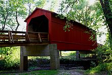
Sugar Creek Covered Bridge
Festivals
Every June the Chatham American Legion Homecoming Festival takes place in the Chatham town square. Each year in July, Chatham is host to the Chatham Sweet Corn Festival and Illinois Championship Cow Chip Throw sponsored by the Chatham Jaycees.[8]
Places of interest
Chatham Railroad Museum (1902)[9]
Caldwell Farmstead (National Register of Historical Places)
Interurban Trail, a mixed-use rails-to-trails trail, (Chatham and Woodside townships, 4.75 mi (7.64 km). in length)
Sugar Creek Covered Bridge is located 5 miles (8.0 km) southeast of Chatham.
Notable people
Kenneth Boyle, Illinois state representative and lawyer
Kelci Bryant, Olympic diver
Gracie Gold, US and Olympic figure skater
Phil Maton, pitcher for the San Diego Padres
Jayson Werth, outfielder for the Toronto Blue Jays, Los Angeles Dodgers, Philadelphia Phillies and Washington Nationals
Ashley A. Woods, comic artist[10]
References
^ "2016 U.S. Gazetteer Files". United States Census Bureau. Retrieved Jun 29, 2017..mw-parser-output cite.citation{font-style:inherit}.mw-parser-output q{quotes:"""""""'""'"}.mw-parser-output code.cs1-code{color:inherit;background:inherit;border:inherit;padding:inherit}.mw-parser-output .cs1-lock-free a{background:url("//upload.wikimedia.org/wikipedia/commons/thumb/6/65/Lock-green.svg/9px-Lock-green.svg.png")no-repeat;background-position:right .1em center}.mw-parser-output .cs1-lock-limited a,.mw-parser-output .cs1-lock-registration a{background:url("//upload.wikimedia.org/wikipedia/commons/thumb/d/d6/Lock-gray-alt-2.svg/9px-Lock-gray-alt-2.svg.png")no-repeat;background-position:right .1em center}.mw-parser-output .cs1-lock-subscription a{background:url("//upload.wikimedia.org/wikipedia/commons/thumb/a/aa/Lock-red-alt-2.svg/9px-Lock-red-alt-2.svg.png")no-repeat;background-position:right .1em center}.mw-parser-output .cs1-subscription,.mw-parser-output .cs1-registration{color:#555}.mw-parser-output .cs1-subscription span,.mw-parser-output .cs1-registration span{border-bottom:1px dotted;cursor:help}.mw-parser-output .cs1-hidden-error{display:none;font-size:100%}.mw-parser-output .cs1-visible-error{font-size:100%}.mw-parser-output .cs1-subscription,.mw-parser-output .cs1-registration,.mw-parser-output .cs1-format{font-size:95%}.mw-parser-output .cs1-kern-left,.mw-parser-output .cs1-kern-wl-left{padding-left:0.2em}.mw-parser-output .cs1-kern-right,.mw-parser-output .cs1-kern-wl-right{padding-right:0.2em}
^ ab "Population and Housing Unit Estimates". Retrieved June 9, 2017.
^ "US Gazetteer files: 2010, 2000, and 1990". United States Census Bureau. 2011-02-12. Retrieved 2011-04-23.
^ "G001 - Geographic Identifiers - 2010 Census Summary File 1". United States Census Bureau. Retrieved 2015-08-02.
^ "Census of Population and Housing". Census.gov. Archived from the original on May 12, 2015. Retrieved June 4, 2015.
^ "CensusViewer". Retrieved 2015-08-12.
^ "American FactFinder". United States Census Bureau. Archived from the original on 2013-09-11. Retrieved 2008-01-31.
^ Chatham Jaycees website. Retrieved 2010-08-21.
^ [1]
^ Jackson, Cheryl V. "Black female characters, artists fight for place in comic book world". Chicago Tribune. Retrieved 2017-11-30.
External links
Village of Chatham official website- Chatham Area Public LIbrary District
Municipalities and communities of Sangamon County, Illinois, United States | ||
|---|---|---|
County seat: Springfield | ||
| Cities |
| |
| Villages |
| |
| Townships |
| |
| Unincorporated communities |
| |
| Footnotes | ‡This city also has portions in adjacent county or counties | |


