Guainía Department
Department of Guainía Departamento de Guainía | |||
|---|---|---|---|
Department | |||
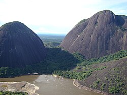 Cerros de Mavecure: Cerro Mono, 480m (left) and Cerro Pajarito, 712m (right) | |||
| |||
 Guainía shown in red | |||
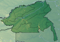 Topography of the department | |||
| Coordinates: 3°51′55″N 67°55′26″W / 3.86528°N 67.92389°W / 3.86528; -67.92389Coordinates: 3°51′55″N 67°55′26″W / 3.86528°N 67.92389°W / 3.86528; -67.92389 | |||
| Country | |||
| Region | Amazon Region | ||
| Capital | Inírida | ||
| Government | |||
| • Governor | Javier Eliecer Zapata Parrado (2016-2019) | ||
| Area | |||
| • Total | 72,238 km2 (27,891 sq mi) | ||
| Area rank | 5th | ||
| Population (2013)[1] | |||
| • Total | 40,203 | ||
| • Rank | 33rd | ||
| • Density | 0.56/km2 (1.4/sq mi) | ||
| Time zone | UTC-05 | ||
| ISO 3166 code | CO-GUA | ||
HDI (2017) | 0.652[2] medium · 32nd | ||


Guainía (Spanish pronunciation: [ɡwaiˈni.a]; Yuri language: "Land of many waters") is a department of Colombia. It is in the east of the country, bordering Venezuela and Brazil. Its capital is Inírida. In 1963 Guainía was split off from Vaupés department. The northern part and the Inírida River are included in the Orinoco basin; the rest is part of the Amazon basin. The Guaviare River is the main area of colonization; many colonos come from the Colombian Andean zone, most of them from Boyacá. They are followed by the llaneros, people from the Eastern plains (Los Llanos). The population is mainly composed of Amerindians, and the largest ethnic groups are the Puinaves (from the makú-puinave family) and the curripacos (from the Arawak family). There are a total of 24 ethnic groups in the department; many of them speak four Indigenous languages besides Spanish and Portuguese.
Municipalities
There is only one municipality in Guainía: Inírida, its capital. The rest of the territory is subdivided in corregimientos departamentales, a pending figure due to public disorder[clarification needed].[3] This case happens only in Amazonas, Vaupés and Vichada. Barranco Minas is the second biggest population and its main corregimiento; it is located on the Guaviare River.
The Guainía corregimientos are:
- Barranco Minas
- Cacahual
- La Guadalupe
- Mapiripana
- Morichal Nuevo
- Pana Pana
- Puerto Colombia
- San Felipe
References
^ "DANE". Archived from the original on November 13, 2009. Retrieved February 13, 2013..mw-parser-output cite.citation{font-style:inherit}.mw-parser-output .citation q{quotes:"""""""'""'"}.mw-parser-output .citation .cs1-lock-free a{background:url("//upload.wikimedia.org/wikipedia/commons/thumb/6/65/Lock-green.svg/9px-Lock-green.svg.png")no-repeat;background-position:right .1em center}.mw-parser-output .citation .cs1-lock-limited a,.mw-parser-output .citation .cs1-lock-registration a{background:url("//upload.wikimedia.org/wikipedia/commons/thumb/d/d6/Lock-gray-alt-2.svg/9px-Lock-gray-alt-2.svg.png")no-repeat;background-position:right .1em center}.mw-parser-output .citation .cs1-lock-subscription a{background:url("//upload.wikimedia.org/wikipedia/commons/thumb/a/aa/Lock-red-alt-2.svg/9px-Lock-red-alt-2.svg.png")no-repeat;background-position:right .1em center}.mw-parser-output .cs1-subscription,.mw-parser-output .cs1-registration{color:#555}.mw-parser-output .cs1-subscription span,.mw-parser-output .cs1-registration span{border-bottom:1px dotted;cursor:help}.mw-parser-output .cs1-ws-icon a{background:url("//upload.wikimedia.org/wikipedia/commons/thumb/4/4c/Wikisource-logo.svg/12px-Wikisource-logo.svg.png")no-repeat;background-position:right .1em center}.mw-parser-output code.cs1-code{color:inherit;background:inherit;border:inherit;padding:inherit}.mw-parser-output .cs1-hidden-error{display:none;font-size:100%}.mw-parser-output .cs1-visible-error{font-size:100%}.mw-parser-output .cs1-maint{display:none;color:#33aa33;margin-left:0.3em}.mw-parser-output .cs1-subscription,.mw-parser-output .cs1-registration,.mw-parser-output .cs1-format{font-size:95%}.mw-parser-output .cs1-kern-left,.mw-parser-output .cs1-kern-wl-left{padding-left:0.2em}.mw-parser-output .cs1-kern-right,.mw-parser-output .cs1-kern-wl-right{padding-right:0.2em}
^ "Sub-national HDI - Area Database - Global Data Lab". hdi.globaldatalab.org. Retrieved 2018-09-13.
^ "Sentencia C-141/01" (in Spanish). Retrieved 2008-07-27.
External links
(in Spanish) Guainía Secretary of Education
- Territorial-Environmental Information System of Colombian Amazon SIAT-AC website
Departments of Colombia | ||||||||
|---|---|---|---|---|---|---|---|---|
 |
| |||||||


